Carmel, Indiana
| Carmel, Indiana | |
|---|---|
| City | |
| City of Carmel | |

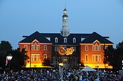
City Hall during CarmelFest
|
|
| Motto: "A Partnership For the Tomorrow" | |
 Location in the state of Indiana |
|
| Coordinates: 39°58′N 86°6′W / 39.967°N 86.100°WCoordinates: 39°58′N 86°6′W / 39.967°N 86.100°W | |
| Country | United States |
| State | Indiana |
| County | Hamilton |
| Township | Clay |
| Government | |
| • Mayor | James Brainard (R) (1996-present) |
| Area | |
| • City | 48.55 sq mi (125.74 km2) |
| • Land | 47.46 sq mi (122.92 km2) |
| • Water | 1.09 sq mi (2.82 km2) |
| Elevation | 853 ft (260 m) |
| Population (2010) | |
| • City | 79,191 |
| • Estimate (2014) | 85,927 |
| • Density | 1,769.9/sq mi (644.39/km2) |
| • Metro | 2,414,639 (23rd) |
| Time zone | EST (UTC-5) |
| • Summer (DST) | EDT (UTC-4) |
| ZIP codes | 46032, 46033, 46082, 46280 |
| Area code(s) | 317 |
| FIPS code | 18-10342 |
| GNIS feature ID | 0432143 |
| Interstate Highways |
|
| U.S. Highways | |
| Website | www |
Carmel /ˈkɑːrməl/ is a suburban city in Hamilton County, Indiana, United States located immediately north of Indianapolis. It has been one of the fastest-growing communities in the country. In 2012, Carmel was selected the Best Place to Live in United States by CNN Money magazine. The population was estimated 85,927 in 2014 by the US Census Bureau, making it the fifth-largest city in Indiana.
Carmel was originally called Bethlehem and, under the latter name, was laid out and platted in 1837. The original settlers were predominantly Quakers. Today, the plot first established in Bethlehem, located at the intersection of Rangeline Road and Main Street, is marked by a clock tower, donated by the local Rotary Club in 2002. A post office was established as Carmel in 1846. The town of Bethlehem was renamed Carmel in 1874, at which time it was incorporated.
In 1924, one of the first automatic traffic signals in the U.S. was installed at the intersection of Main Street and Rangeline Road. The signal was the invention of Leslie Haines and is currently in the old train station on the Monon Trail.
The Carmel Monon Depot, John Kinzer House, and Thornhurst Addition are listed on the National Register of Historic Places.
According to the 2010 census, Carmel has a total area of 48.545 square miles (125.73 km2), of which 47.46 square miles (122.92 km2) (or 97.76%) is land and 1.085 square miles (2.81 km2) (or 2.24%) is water.
Major east–west streets in Carmel generally end in a 6, and include 96th Street (the Southern border), 106th, 116th, 126th, 131st, 136th and 146th (the Northern Border). The numbering system is aligned to that of Marion and Hamilton counties. Main Street (131st) runs East-West through Carmel's Art & Design District; Carmel Drive runs East-West through a main shopping area; and City Center Drive runs East-West near Carmel's new City Center project.
...
Wikipedia
