Caribbean Plate
| Caribbean Plate | |
|---|---|
 |
|
| Type | Minor |
| Approximate area | 3,300,000 km2 |
| Movement1 | north-west |
| Speed1 | 10-11mm/year |
| Features | Central America, Cuba, Hispaniola. Caribbean Sea |
| 1Relative to the African Plate | |
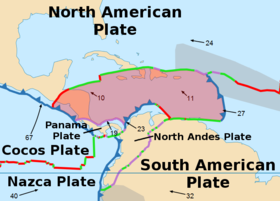
The Caribbean Plate is a mostly oceanic tectonic plate underlying Central America and the Caribbean Sea off the north coast of South America.
Roughly 3.2 million square kilometers (1.2 million square miles) in area, the Caribbean Plate borders the North American Plate, the South American Plate, the Nazca Plate and the Cocos Plate. These borders are regions of intense seismic activity, including frequent earthquakes, occasional tsunamis, and volcanic eruptions.
The northern boundary with the North American plate is a transform or strike-slip boundary which runs from the border area of Belize, Guatemala (Motagua Fault), and Honduras in Central America, eastward through the Cayman trough on south of the southeast coast of Cuba, and just north of Hispaniola, Puerto Rico, and the Virgin Islands. Part of the Puerto Rico Trench, the deepest part of the Atlantic Ocean (roughly 8,400 meters), lies along this border. The Puerto Rico trench is at a complex transition from the subduction boundary to the south and the transform boundary to the west.
The eastern boundary is a subduction zone, the Lesser Antilles subduction zone, where oceanic crust of the South American Plate is being subducted under the Caribbean Plate. Subduction forms the volcanic islands of the Lesser Antilles Volcanic Arc from the Virgin Islands in the north to the islands off the coast of Venezuela in the south. This boundary contains seventeen active volcanoes, most notably Soufriere Hills on Montserrat; Mount Pelée on Martinique; La Grande Soufrière on Guadeloupe; Soufrière Saint Vincent on Saint Vincent; and the submarine volcano Kick 'em Jenny which lies about 10 km north of Grenada. Large historical earthquakes in 1839 and 1843 in this region are possibly megathrust earthquakes.
...
Wikipedia
