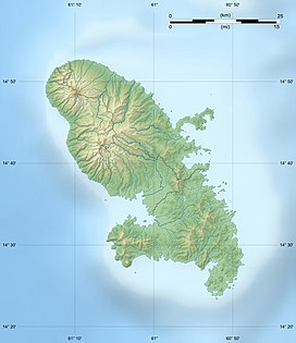
Mount Pelée
| Mount Pelée | |
|---|---|
 |
|
| Highest point | |
| Elevation | 1,397 m (4,583 ft) |
| Prominence | 1,397 m (4,583 ft) |
| Coordinates | 14°49′0″N 61°10′0″W / 14.81667°N 61.16667°WCoordinates: 14°49′0″N 61°10′0″W / 14.81667°N 61.16667°W |
| Geography | |
| Geology | |
| Mountain type | Stratovolcano |
| Volcanic arc/belt | Lesser Antilles Volcanic Arc |
| Last eruption | 1929–1932 |
| Climbing | |
| Easiest route | walk |
Mount Pelée (pronounced /pəˈleɪ/; French: Montagne Pelée meaning "bald mountain" or "peeled" mountain") is a semi-active volcano at the northern end of Martinique, an island and French overseas department in the Lesser Antilles island arc of the Caribbean. Its volcanic cone is composed of layers of volcanic ash and hardened lava. The volcano is currently in a quiescent state, which means it is not active, but is registering seismic activity.
The stratovolcano is famous for its eruption in 1902 and the destruction that resulted, dubbed the worst volcanic disaster of the 20th century. The eruption killed about 30,000 people. Most deaths were caused by pyroclastic flows which completely destroyed the city of Saint-Pierre (at that time, the largest city on the island.), within minutes of the eruption.
The eruption left only two survivors in the direct path of the flows: Louis-Auguste Cyparis survived because he was in a poorly ventilated, dungeon-like jail cell; Léon Compère-Léandre, living on the edge of the city, escaped with severe burns. Havivra Da Ifrile, a young girl, reportedly escaped with injuries during the eruption by taking a small boat to a cave down shore, and was later found adrift 3 km (1.9 mi) from the island, unconscious. The event marked the only major volcanic disaster in the history of France and its overseas territories.
...
Wikipedia

