Capture of Quebec
|
Quebec Québec (French) |
|||
|---|---|---|---|
|
|||
| Motto: Je me souviens (French) ("I remember") |
|||
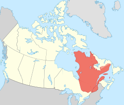
 Map of Canada with Quebec highlighted |
|||
| Confederation | July 1, 1867 (1st, with ON, NS, NB) | ||
| Capital | Quebec City | ||
| Largest city | Montreal | ||
| Largest metro | Greater Montreal | ||
| Government | |||
| • Type | Constitutional monarchy | ||
| • Lieutenant Governor | J. Michel Doyon | ||
| • Premier | Philippe Couillard (Quebec Liberal) | ||
| Legislature | National Assembly of Quebec | ||
| Federal representation | (in Canadian Parliament) | ||
| House seats | 78 of 338 (23.1%) | ||
| Senate seats | 24 of 105 (22.9%) | ||
| Area | |||
| • Total | 1,542,056 km2 (595,391 sq mi) | ||
| • Land | 1,365,128 km2 (527,079 sq mi) | ||
| • Water | 176,928 km2 (68,312 sq mi) 11.5% | ||
| Area rank | Ranked 2nd | ||
| 15.4% of Canada | |||
| Population (2016) | |||
| • Total | 8,164,361 | ||
| • Estimate (2017 Q1) | 8,356,851 | ||
| • Rank | Ranked 2nd | ||
| • Density | 5.98/km2 (15.5/sq mi) | ||
| Demonym(s) | in English: Quebecer or Quebecker, in French: Québécois (m) Québécoise (f) |
||
| Official languages | French | ||
| GDP | |||
| • Rank | 2nd | ||
| • Total (2015) | C$380.972 billion | ||
| • Per capita | C$46,126 (10th) | ||
| Time zone | UTC−5, −4 | ||
| Postal abbr. | QC | ||
| Postal code prefix | G, H, J | ||
| ISO 3166 code | CA-QC | ||
| Flower | Blue flag iris | ||
| Tree | Yellow birch | ||
| Bird | Snowy owl | ||
| Website | www |
||
| Rankings include all provinces and territories | |||
Quebec (/kwɪˈbɛk/ (![]() listen) or /kɪˈbɛk/; French: Québec [kebɛk] (
listen) or /kɪˈbɛk/; French: Québec [kebɛk] (![]() listen)) is one of the 13 provinces and territories of Canada. It is bordered to the west by the province of Ontario, James Bay, and Hudson Bay; to the north by Hudson Strait and Ungava Bay; to the east by the Gulf of Saint Lawrence and the province of Newfoundland and Labrador; and to the south by the province of New Brunswick and the US states of Maine, New Hampshire, Vermont, and New York. It also shares maritime borders with Nunavut, Prince Edward Island, and Nova Scotia. Quebec is Canada's largest province by area and its second-largest administrative division; only the territory of Nunavut is larger. It is historically and politically considered to be part of Central Canada (with Ontario).
listen)) is one of the 13 provinces and territories of Canada. It is bordered to the west by the province of Ontario, James Bay, and Hudson Bay; to the north by Hudson Strait and Ungava Bay; to the east by the Gulf of Saint Lawrence and the province of Newfoundland and Labrador; and to the south by the province of New Brunswick and the US states of Maine, New Hampshire, Vermont, and New York. It also shares maritime borders with Nunavut, Prince Edward Island, and Nova Scotia. Quebec is Canada's largest province by area and its second-largest administrative division; only the territory of Nunavut is larger. It is historically and politically considered to be part of Central Canada (with Ontario).
...
Wikipedia


