Cappadoccia
| Cappadocia | |
|---|---|
| Ancient region of Central Anatolia Region, today's Turkey Quasi-independent in various forms until AD 17 |
|

|
|
 |
|
| Coordinates: Coordinates: 38°39′30″N 34°51′13″E / 38.65833°N 34.85361°E | |
| Persian satrapy | Katpatuka |
| Roman province | Cappadocia |
| Capitals | Kayseri, Nevşehir |
 |
|
| UNESCO World Heritage Site | |
|---|---|
| Official name | Göreme National Park and the Rock Sites of Cappadocia |
| Location | Turkey |
| Coordinates | 38°40′14″N 34°50′21″E / 38.67056°N 34.83917°E |
| Criteria | Mixed: i, iii, v, vii |
| Reference | 357 |
| Inscription | 1985 (9th Session) |
|
[]
|
|
Cappadocia (/kæpəˈdoʊʃə/; also Capadocia; Turkish: Kapadokya, Greek: Καππαδοκία Kappadokía, from Old Persian: ) is a historical region in Central Anatolia, largely in the Nevşehir, Kayseri, Kırşehir, Aksaray, and Niğde Provinces in Turkey.
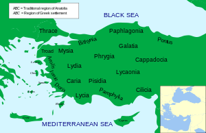
According to Herodotus, in the time of the Ionian Revolt (499 BC), the Cappadocians were reported as occupying a region from Mount Taurus to the vicinity of the Euxine (Black Sea). Cappadocia, in this sense, was bounded in the south by the chain of the Taurus Mountains that separate it from Cilicia, to the east by the upper Euphrates, to the north by Pontus, and to the west by Lycaonia and eastern Galatia.
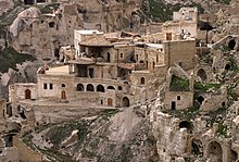
The name, traditionally used in Christian sources throughout history, continues in use as an international tourism concept to define a region of exceptional natural wonders, in particular characterized by fairy chimneys and a unique historical and cultural heritage.
...
Wikipedia

