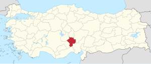
Niğde Province
|
Niğde Province Niğde ili |
|
|---|---|
| Province of Turkey | |
 Location of Niğde Province in Turkey |
|
| Country | Turkey |
| Region | Central Anatolia |
| Subregion | Kırıkkale |
| Government | |
| • Electoral district | Niğde |
| Area | |
| • Total | 7,312 km2 (2,823 sq mi) |
| Population (2010) | |
| • Total | 337,931 |
| • Density | 46/km2 (120/sq mi) |
| Area code(s) | 0388 |
| Vehicle registration | 51 |
Niğde Province (Turkish: Niğde ili) is a province in the southern part of Central Anatolia, Turkey. Population is 341,412 (2013 est) of which 141,360 live in the city of Niğde. The population was 348,081 in 2000 and 305,861 in 1990. It covers an area of 7,312 km². Neighbouring provinces are Kayseri, Adana, Mersin, Konya, Aksaray and Nevşehir.
The province is surrounded on three sides by ranges of the Taurus Mountains, including Mount Hasan and the Melendiz mountains. To the west lies the plain of Emen, which opens up into the wide plain of Konya. The plain is covered with nutritious volcanic soil and Niğde is a successful agricultural region, particularly apples and potatoes.
Surrounded by mountains and at a fairly high altitude the area has a dry and chilly climate and is exposed to snows brought by cold north winds in winter. Average rainfall 0.9 mm, 78.5 mm in April, practically zero in July and August. Therefore, the hillsides are more or less bare of vegetation, with some forest at the higher altitudes.
(see Niğde for more information about the provincial capital city).
Niğde province is divided into 6 districts (capital district in bold):
Some of the towns within these districts are Bademdere, Bahçeli, Çiftehan, Darboğaz, Fertek and Kemerhisar.
...
Wikipedia
