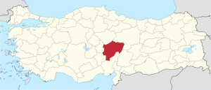
Kayseri Province
|
Kayseri Province Kayseri ili |
|
|---|---|
| Province of Turkey | |
 Location of Kayseri Province in Turkey |
|
| Country | Turkey |
| Region | Central Anatolia |
| Subregion | Kayseri |
| Government | |
| • Electoral district | Kayseri |
| • Governor | Süleyman Kamçı |
| Area | |
| • Total | 16,917 km2 (6,532 sq mi) |
| Population (2010) | |
| • Total | 1,234,651 |
| • Density | 73/km2 (190/sq mi) |
| Area code(s) | 0352 |
| Vehicle registration | 38 |
The Kayseri Province (Turkish: Kayseri ili) is situated in central Turkey. The population is 1,255,349 of which around 1,000,000 live in the city of Kayseri. It covers an area of 16,917 km² and it borders with Sivas, Adana, Niğde, Kahramanmaraş, Yozgat and Nevşehir provinces.
The province is an area that has been linked with mythological stories as well as important figures in Turkish history. It is located in Anatolia, and surrounded by the Mount Erciyes, the Mount Hasan and the Mount Ali. The Ali mountain is named like that in honor of Ali Baba, who is said to have lived in the area.
Kayseri was first known as the city of Masaka. Later, during the Roman period, the province's name was changed to Kaesarea, then Kayzer before becoming known with its modern name of Kayseri. Danishmend Gazi conquered Kayseri in 1084. The Seljuk Empire then modernised the province, with new buildings and mosques being built around. During this period, the Şifahane, Kayseri's first hospital, and perhaps the first hospital in all of Anatolia, was built. It was built in honor of Princess Gevher Nesibe Hatun, daughter of the Sultan. She died of a disease at a young age. Construction of the hospital was completed in 1206.
Later on, Kayseri became a cultural mecca of poets, artists in Turkey. Seyyid Burhaneddin lived there, and so did others such as Kadı Burhaneddin and Seyrani, among many others. Seynari was born in 1807. Sinan the Great, an Ottoman architect, was also from Kayseri.
...
Wikipedia
