Cilicia
| Cilicia | |
|---|---|
| Ancient region of Anatolia | |
| Location | South Anatolia |
| State existed: | 16th–14th century BC (as Kizzuwatna) 12th–8th century BC (as Khilikku, Tabal, Quwê) until 546 BC |
| Language | Luwian |
| Historical capitals | Tarsus |
| Persian satrapy | Cilicia |
| Roman province | Cilicia |
| Area | 32,000 km2 (12,300 sq mi) |
 |
|
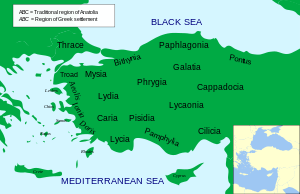
In antiquity, Cilicia (/sɪˈlɪʃiə/) was the south coastal region of Asia Minor and existed as a political entity from Hittite times into the Armenian Kingdom of Cilicia during the late Byzantine Empire. Extending inland from the southeastern coast of modern Turkey, Cilicia is due north and northeast of the island of Cyprus and corresponds to the modern region of Çukurova in Turkey.
Cilicia extended along the Mediterranean coast east from Pamphylia, to the Nur Mountains, which separated it from Syria. North and east of Cilicia lie the rugged Taurus Mountains that separate it from the high central plateau of Anatolia, which are pierced by a narrow gorge, called in antiquity the Cilician Gates. Ancient Cilicia was naturally divided into Cilicia Trachaea and Cilicia Pedias by the Limonlu River. Salamis, the city on the east coast of Cyprus, was included in its administrative . The Greeks invented for Cilicia an eponymous Hellene founder in the purely mythical Cilix, but the historic founder of the dynasty that ruled Cilicia Pedias was Mopsus, identifiable in Phoenician sources as Mpš, the founder of Mopsuestia who gave his name to an oracle nearby.Homer mentions the people of Mopsus, identified as Cilices (Κίλικες), as from the Troad in the northernwesternmost part of Anatolia.
...
Wikipedia
