Cagayan River
| Cagayan River (Bannag) | |
| Rio Grande de Cagayan | |
| River | |
| Country | |
|---|---|
| Island | Luzon |
| Region | Cagayan Valley |
| Provinces | |
| Cities and municipalities |
|
| Tributaries | |
| - left | |
| - right | |
| Source | |
| - location | Caraballo Mountains |
| - coordinates | 16°11′08″N 121°08′39″E / 16.18556°N 121.14417°E |
| Mouth | |
| - location | Babuyan Channel, Aparri |
| - elevation | 0 m (0 ft) |
| - coordinates | 18°20′N 121°37′E / 18.333°N 121.617°ECoordinates: 18°20′N 121°37′E / 18.333°N 121.617°E |
| Length | 354 km (220 mi) |
| Basin | 27,280 km2 (10,533 sq mi) |
|
Drainage area of the river and its tributaries in northeastern Luzon
|
|
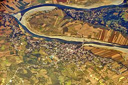
The Cagayan River, also known as the Rio Grande de Cagayan, is the longest and 2nd largest river in the Philippine Archipelago After Rio Grande de Mindanao. It is located in the Cagayan Valley region in northeastern part of Luzon Island and traverses the provinces of Nueva Vizcaya, Quirino, Isabela and Cagayan.
The river's headwaters are at the Caraballo Mountains of the Central Luzon at an elevation of approximately 1,524 metres (5,000 ft). The river flows north for some 354 kilometres (220 mi) to its mouth at the Babuyan Channel near the town of Aparri, Cagayan. The river drops rapidly to 91 metres (299 ft) above sea level some 227 kilometres (141 mi) from the river mouth. Its principal tributaries are the Pinacanauan, Chico, Siffu, Mallig, Magat and Ilagan Rivers.
Magat River is the largest tributary with an estimated annual discharge of 9,808 million cubic meters. It lies in the southwestern portion of the basin, stretching approximately 150 kilometres (93 mi) from Nueva Vizcaya down to its confluence with Cagayan River about 55 kilometres (34 mi) from the river mouth.
...
Wikipedia


