San Pablo, Isabela
| San Pablo | ||
|---|---|---|
| Municipality | ||
 |
||
|
||
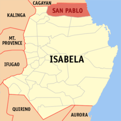
 Map of Isabela showing the location of San Pablo |
||
| Location within the Philippines | ||
| Coordinates: 17°28′N 121°59′E / 17.467°N 121.983°ECoordinates: 17°28′N 121°59′E / 17.467°N 121.983°E | ||
| Country | Philippines | |
| Region | Cagayan Valley (Region II) | |
| Province | Isabela | |
| District | 1st District of Isabela | |
| Barangays | 17 | |
| Government | ||
| • Mayor | Antonio Jose T. Miro III | |
| Area | ||
| • Total | 637.90 km2 (246.29 sq mi) | |
| Population (2015 census) | ||
| • Total | 25,384 | |
| • Density | 40/km2 (100/sq mi) | |
| Time zone | PST (UTC+8) | |
| ZIP code | 3329 | |
| Dialing code | +63 (0)78 | |
| Income class | 2nd municipal income class | |
| 023133000 | ||
| Electorate | 14,309 voters as of 2016 | |
| Website | www |
|
San Pablo is a second class municipality in the province of Isabela, Philippines. According to the 2015 census, it has a population of 25,384 people.
San Pablo is politically subdivided into 17 barangays.
...
Wikipedia


