Enrile, Cagayan
| Enrile | ||
|---|---|---|
| Municipality | ||
|
||
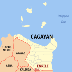
 Map of Cagayan showing the location of Enrile |
||
| Location within the Philippines | ||
| Coordinates: 17°33′N 121°42′E / 17.55°N 121.7°ECoordinates: 17°33′N 121°42′E / 17.55°N 121.7°E | ||
| Country | Philippines | |
| Region | Cagayan Valley (Region II) | |
| Province | Cagayan | |
| District | 3rd District | |
| Barangays | 22 | |
| Government | ||
| • Mayor | Kim S. Tavas Turingan | |
| Area | ||
| • Total | 184.50 km2 (71.24 sq mi) | |
| Population (2015 census) | ||
| • Total | 35,834 | |
| • Density | 190/km2 (500/sq mi) | |
| Time zone | PST (UTC+8) | |
| ZIP code | 3501 | |
| IDD : area code | +63 (0)78 | |
| Income class | 3rd class | |
Enrile is a third class municipality in the province of Cagayan, Philippines. According to the 2015 census, it has a population of 35,834 people.
The municipality was named after Spanish governor-general Pasqual Enrile y Alcedo.
Enrile is politically subdivided into 22 barangays.
In the 2015 census, the population of Enrile, Cagayan, was 35,834 people, with a density of 190 inhabitants per square kilometre or 490 inhabitants per square mile.
...
Wikipedia


