Alcala, Cagayan
| Alcala | ||
|---|---|---|
| Municipality | ||
|
||
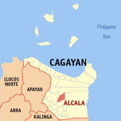
 Map of Cagayan showing the location of Alcala |
||
| Location within the Philippines | ||
| Coordinates: 17°54′N 121°40′E / 17.9°N 121.67°ECoordinates: 17°54′N 121°40′E / 17.9°N 121.67°E | ||
| Country | Philippines | |
| Region | Cagayan Valley (Region II) | |
| Province | Cagayan | |
| District | 1st District | |
| Barangays | 25 | |
| Government | ||
| • Mayor | Criselda "Dadang" I. Antonio | |
| Area | ||
| • Total | 187.20 km2 (72.28 sq mi) | |
| Population (2015 census) | ||
| • Total | 38,883 | |
| • Density | 210/km2 (540/sq mi) | |
| Time zone | PST (UTC+8) | |
| ZIP code | 3507 | |
| IDD : area code | +63 (0)78 | |
| Income class | 3rd class | |
Alcala is a third class municipality in the province of Cagayan, Philippines. According to the 2015 census, it has a population of 38,883 people.
Alcala is home to the Saint Philomene Church, regarded as the widest church in the Cagayan Valley.
Alcala Milk Candy is a famous product of this municipality.
Alcala is politically subdivided into 25 barangays.
In the 2015 census, the population of Alcala, Cagayan, was 38,883 people, with a density of 210 inhabitants per square kilometre or 540 inhabitants per square mile.
...
Wikipedia


