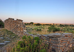
Butterfield Overland Mail in Texas
| Butterfield Overland Mail | |
|---|---|

|
|
| Type | historic trail |
| Location | New Mexico Territory near Anthony - Indian Territory near Sherman |
| Official name: Butterfield Overland Mail Corridor | |
| Type | U.S. historic district |
| Designated | August 27, 2014 |
| Reference no. | 14000524 |
| Location | Guadalupe Mountains National Park |
| Coordinates | 31°53′36″N 104°48′57″W / 31.89333°N 104.81583°W |
| Area | 2,401.3 acres (971.8 ha) |
In Texas, the Butterfield Overland Mail service created by Congress on March 3, 1857, operated until March 30, 1861. The route that was operated extended from San Francisco, California to Los Angeles, then across the Colorado Desert to Fort Yuma, then across New Mexico Territory via, Tucson and Mesilla, New Mexico to Franklin, Texas, midpoint on the route. The route through Texas followed first the northern route to the Pecos River and downstream to Horse Head Crossing. The route in West Texas was changed in 1859, in order to secure a better water supply on the route and to provide mail service to a more settled area, the stages between Franklin and the Pecos River followed the San Antonio-El Paso Road to and then turned east to Horsehead Crossing. From Horsehead Crossing the route crossed Texas to the Red River and into Indian Territory. In 1860 the route was changed to another route from Jacksboro to Sherman via Decatur due to the building of a new toll bridge at Bridgeport, that avoided delays crossing the West Fork of the Trinity River when it was flooded. From Colberts Ferry the route went on to Fort Smith, then up across Arkansas and southwest Missouri to Tipton with the final leg by train to St. Louis. The Texas mail route was so long that the route there, like that in California, was divided into two divisions each under a superintendent.
...
Wikipedia
