Mesilla, New Mexico
| Mesilla, New Mexico | |
|---|---|
| Town | |

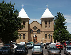
Basilica of San Albino, on the Mesilla plaza
|
|
 Location within Doña Ana County and New Mexico |
|
| Location in the United States | |
| Coordinates: 32°16′22″N 106°48′3″W / 32.27278°N 106.80083°WCoordinates: 32°16′22″N 106°48′3″W / 32.27278°N 106.80083°W | |
| Country | United States |
| State | New Mexico |
| County | Doña Ana |
| Area | |
| • Total | 6.7 sq mi (17.4 km2) |
| • Land | 6.7 sq mi (17.4 km2) |
| • Water | 0.0 sq mi (0.0 km2) |
| Elevation | 3,881 ft (1,183 m) |
| Population (2010) | |
| • Total | 2,196 |
| • Density | 326/sq mi (125.9/km2) |
| Time zone | Mountain (MST) (UTC-7) |
| • Summer (DST) | MDT (UTC-6) |
| ZIP code | 88046 |
| Area code(s) | 575 |
| FIPS code | 35-48060 |
| GNIS feature ID | 0920645 |
| Website | mesillanm |
Mesilla (also known as La Mesilla and Old Mesilla) is a town in Doña Ana County, New Mexico, United States. The population was 2,196 at the 2010 census. It is part of the Las Cruces Metropolitan Statistical Area.
During the American Civil War, Mesilla briefly served as capital of the Confederate Territory of Arizona.
The Mesilla Plaza is a National Historic Landmark.
The village of Mesilla was incorporated in 1848, after the Treaty of Guadalupe Hidalgo moved the U.S.–Mexico border south of the village of Doña Ana, placing it in the United States. A small group of citizens, unhappy at being part of the United States, decided to move south of the border. They settled in Mesilla at this time.
By 1850, Mesilla was an established colony. By this time, its people were under constant threat of attack from the Apache. By 1851, the attacks caused the United States to take action to protect its people just to the north of the border, in the Mesilla Valley. They did this by creating Fort Fillmore. As a result of the fort, the United States declared the Mesilla Valley region part of the United States. Mexico also claimed this strip of land, causing it to become known as "No Mans Land". This boundary dispute, which was officially caused by a map error, was resolved in 1853 with the Gadsden Purchase. Mesilla became a part of the United States, as well as the southern part of New Mexico and Arizona.
...
Wikipedia

