Burr Ridge, Illinois
| Burr Ridge, Illinois | |
|---|---|
| Village | |
| Village of Burr Ridge | |
 |
|
| Motto: "A very special place" | |
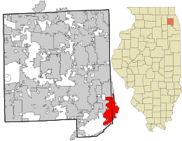
 Location in DuPage County and the state of Illinois. |
|
| Coordinates ("): 41°45′11″N 87°55′12″W / 41.75306°N 87.92000°WCoordinates: 41°45′11″N 87°55′12″W / 41.75306°N 87.92000°W | |
| Country |
|
| State | Illinois |
| Counties | DuPage, Cook |
| Townships | Downers Grove, Lyons |
| Incorporated | 1956 |
| Government | |
| • Type | Council-manager |
| • Mayor | Mickey Straub |
| Area | |
| • Total | 7.14 sq mi (18.5 km2) |
| • Land | 7.00 sq mi (18.1 km2) |
| • Water | 0.14 sq mi (0.4 km2) 1.96% |
| Population (2010) | |
| • Total | 10,559 |
| • Density | 1,508.4/sq mi (582.4/km2) |
| Up 1.45% from 2000 | |
| Standard of living (2007-11) | |
| • Per capita income | $81,192 |
| • Home value | $679,400 |
| ZIP code(s) | 60527 |
| Area code(s) | 630 and 331 |
| Geocode | 17-09980 |
| Website | www |
Burr Ridge (formerly Harvester) is a suburb of Chicago, in Cook and DuPage counties, Illinois, United States. The village is listed among the top wealthiest towns in Illinois and is locally known for its large beautiful residences. The population was 10,559 at the 2010 census.
Burr Ridge is located at 41°45′11″N 87°55′12″W / 41.75306°N 87.92000°W (41.753030, -87.919998).
According to the 2010 census, Burr Ridge has a total area of 7.141 square miles (18.50 km2), of which 7 square miles (18.13 km2) (or 98.03%) is land and 0.141 square miles (0.37 km2) (or 1.97%) is water.
Burr Ridge lies in both Du Page and Cook counties. The village is bordered by Hinsdale to the north, Western Springs to the northeast, Indian Head Park to the east, Willow Springs to the south and southeast, and Willowbrook to the west, along with several unincorporated areas.
Burr Ridge's gently rolling hills were carved by glaciers at the end of the last ice age, and most of the village lies on the Valparaiso Moraine. Flagg Creek, a tributary of the Des Plaines River, runs through town.
...
Wikipedia
