Brecksville, Ohio
| Brecksville, Ohio | |
|---|---|
| City | |
![Jonas Coonrad House in Brecksville [1]](http://upload.wikimedia.org/wikipedia/commons/thumb/3/38/Jonas_Coonrad_House_NPS.jpg/250px-Jonas_Coonrad_House_NPS.jpg)
Jonas Coonrad House in Brecksville
|
|
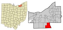
 Location in Cuyahoga County and the state of Ohio. |
|
| Coordinates: 41°18′36″N 81°37′44″W / 41.31000°N 81.62889°WCoordinates: 41°18′36″N 81°37′44″W / 41.31000°N 81.62889°W | |
| Country | United States |
| State | Ohio |
| County | Cuyahoga |
| Government | |
| • Mayor | Jerry N. Hruby (R) |
| Area | |
| • Total | 19.68 sq mi (50.97 km2) |
| • Land | 19.57 sq mi (50.69 km2) |
| • Water | 0.11 sq mi (0.28 km2) |
| Elevation | 889 ft (271 m) |
| Population (2010) | |
| • Total | 13,656 |
| • Estimate (2012) | 13,536 |
| • Density | 697.8/sq mi (269.4/km2) |
| Time zone | Eastern (EST) (UTC-5) |
| • Summer (DST) | EDT (UTC-4) |
| ZIP code | 44141 |
| Area code(s) | 440 |
| FIPS code | 39-08364 |
| GNIS feature ID | 1064483 |
| Website | http://www.brecksville.oh.us/ |
Brecksville is a city in Cuyahoga County, Ohio, United States, and a suburb in the Greater Cleveland area. The city's population was 13,656 at the 2010 census.
Brecksville was founded in 1811, four years after several men — including Colonel John Breck — purchased the surrounding area. After the land was surveyed, Seth Payne, one of the surveyors, brought his family and settled in the area in June 1811, and he was soon followed by many other families. Although Colonel Breck never lived in Brecksville, his three sons did, and members of his family continued to live in Brecksville until 1934, when his great-grandson Dr. Theodore Breck died. A comprehensive early historical account of Brecksville was written by William R. Coates and published by The American Historical Society in 1924.
Brecksville was incorporated as a village in 1921, and it gained the status of city in 1960.
Brecksville is located at 41°18′36″N 81°37′44″W / 41.31000°N 81.62889°W (41.309904, -81.628894).
According to the United States Census Bureau, the city has a total area of 19.68 square miles (50.97 km2), of which 19.57 square miles (50.69 km2) is land and 0.11 square miles (0.28 km2) is water. Brecksville's eastern border is traversed by the Cuyahoga River and borders Sagamore Hills Township and Boston Township, southern border Richfield Township (all three townships in Summit County), western border Broadview Heights and northern border Independence.
...
Wikipedia
