Independence, Ohio
| Independence, Ohio | ||
|---|---|---|
| City | ||

Independence Presbyterian Church, built 1855
|
||
|
||
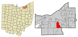
 Location in Cuyahoga County and the state of Ohio. |
||
 Location of Ohio in the United States |
||
| Coordinates: 41°22′55″N 81°38′27″W / 41.38194°N 81.64083°WCoordinates: 41°22′55″N 81°38′27″W / 41.38194°N 81.64083°W | ||
| Country | United States | |
| State | Ohio | |
| County | Cuyahoga | |
| Government | ||
| • Type | Mayor-council | |
| • Mayor | Anthony L. Togliatti (D) | |
| Area | ||
| • Total | 9.64 sq mi (24.97 km2) | |
| • Land | 9.54 sq mi (24.71 km2) | |
| • Water | 0.10 sq mi (0.26 km2) | |
| Elevation | 863 ft (263 m) | |
| Population (2010) | ||
| • Total | 7,133 | |
| • Estimate (2012) | 7,136 | |
| • Density | 747.7/sq mi (288.7/km2) | |
| census | ||
| Time zone | EST (UTC-4) | |
| • Summer (DST) | EDT (UTC-4) | |
| Zip code | 44131 | |
| Area code(s) | 216 | |
| FIPS code | 39-37240 | |
| GNIS feature ID | 1064885 | |
| Website | http://www.independenceohio.org | |
Independence is a city in Cuyahoga County, Ohio, United States. As of the 2010 census, the city population was 7,133.
Independence was originally Center, and under the latter name was laid out in 1830.
Independence is located at 41°22′55″N 81°38′27″W / 41.38194°N 81.64083°W.
According to the United States Census Bureau, the city has a total area of 9.64 square miles (24.97 km2), of which 9.54 square miles (24.71 km2) is land and 0.10 square miles (0.26 km2) is water.
Independence is also the intersection of I-480 and I-77. The I-77/I-480 interchange or the cloverleaf interchange as Clevelanders call it, is the biggest interchange in Ohio. The cloverleaf opened in 1940, but construction of the Willow Freeway, which became I-77, was stalled by World War II until the 1950s. In the late 1970s I-480 connected into I-77. This interchange is similar to interchanges in Los Angeles. The original 1939 cloverleaf is still in existence on Granger and Brecksville Roads. This is still in use today, but not by as many cars because of I-77.
As of the census of 2010, there were 7,133 people, 2,770 households, and 2,054 families residing in the city. The population density was 747.7 inhabitants per square mile (288.7/km2). There were 2,868 housing units at an average density of 300.6 per square mile (116.1/km2). The racial makeup of the city was 96.6% White, 0.4% African American, 0.1% Native American, 1.9% Asian, 0.2% from other races, and 0.8% from two or more races. Hispanic or Latino of any race were 1.1% of the population.
...
Wikipedia

