Bleecker, New York
| Bleecker, New York | |
|---|---|
| Town | |

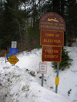
Signage along County Route 125 entering the town of Bleecker and Fulton County
|
|
| Location within the state of New York | |
| Coordinates: 43°9′29″N 74°23′21″W / 43.15806°N 74.38917°W | |
| Country | United States |
| State | New York |
| County | Fulton |
| Government | |
| • Type | Town Council |
| • Town Supervisor | David Howard (R) |
| • Town Council |
Members' List
|
| Area | |
| • Total | 59.4 sq mi (153.9 km2) |
| • Land | 57.1 sq mi (148.0 km2) |
| • Water | 2.3 sq mi (5.9 km2) |
| Elevation | 1,417 ft (432 m) |
| Population (2010) | |
| • Total | 533 |
| • Density | 9/sq mi (3.6/km2) |
| Time zone | Eastern (EST) (UTC-5) |
| • Summer (DST) | EDT (UTC-4) |
| ZIP code | 12078 |
| Area code(s) | 518 |
| FIPS code | 36-06882 |
| GNIS feature ID | 0978737 |
Bleecker is a town in Fulton County, New York, United States. The population was 533 at the 2010 census. The name is from Barent Bleecker, one of the original landowners of the region.
Bleecker is north of the cities of Gloversville and Johnstown, in the northern part of the county.
The first permanent settlements began around 1800 at Lindsleys Corners, although land sales took place before then.
The town was established in 1831 from part of the town of Johnstown, but did not arrive at its current dimensions until 1842. Part of Bleecker was returned to Johnstown in 1841, and another part was added to the town of Caroga in 1842.
Lumbering and tanning were important early industries. Around 1860 the maximum population, about 1,060, was attained; since then it has decreased.
According to the United States Census Bureau, the town has a total area of 59.4 square miles (153.9 km2), of which 57.1 square miles (148.0 km2) is land and 2.3 square miles (5.9 km2), or 3.85%, is water.
The north town line is the border of Hamilton County. The town is inside the Adirondack Park.
As of the census of 2000, there were 573 people, 232 households, and 173 families residing in the town. The population density was 10.0 people per square mile (3.9/km²). There were 429 housing units at an average density of 7.5 per square mile (2.9/km²). The racial makeup of the town was 98.08% White, 0.17% Native American, 0.87% Asian, 0.35% from other races, and 0.52% from two or more races. Hispanic or Latino of any race were 0.35% of the population.
...
Wikipedia

