Benicia, California
| City of Benicia | |
|---|---|
| City | |

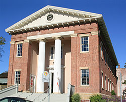
California's third capitol at Benicia. The Senate chambers on first floor, and the Assembly chambers above
|
|
| Motto: "It's better in Benicia!" | |
 Location in Solano County and the state of California |
|
| Location in the United States | |
| Coordinates: 38°3′48″N 122°9′22″W / 38.06333°N 122.15611°WCoordinates: 38°3′48″N 122°9′22″W / 38.06333°N 122.15611°W | |
| Country |
|
| State |
|
| County | Solano |
| Incorporated | March 27, 1850 |
| Government | |
| • Mayor | Elizabeth Patterson |
| • State senator | Bill Dodd (D) |
| • Assemblymember | Tim Grayson (D) |
| • U. S. rep. | Mike Thompson (D) |
| Area | |
| • Total | 15.720 sq mi (40.714 km2) |
| • Land | 12.929 sq mi (33.486 km2) |
| • Water | 2.791 sq mi (7.229 km2) 17.75% |
| Elevation | 26 ft (8 m) |
| Population (April 1, 2010) | |
| • Total | 26,997 |
| • Estimate (2013) | 27,618 |
| • Density | 1,700/sq mi (660/km2) |
| Time zone | Pacific (UTC−8) |
| • Summer (DST) | PDT (UTC−7) |
| ZIP code | 94510 |
| Area code | 707 |
| FIPS code | 06-05290 |
| GNIS feature IDs | 0277472, 2409833 |
| Website | www |
Benicia (/bəˈniːʃə/ bə-NEESH-ə; Spanish pronunciation: [beˈnisja]) is a waterside city in Solano County, California, United States. It served as the state capital for nearly thirteen months from 1853 to 1854. The population was 26,997 at the 2010 census. The city is located in the San Francisco Bay Area along the north bank of the Carquinez Strait. Benicia is just east of Vallejo and across the strait from Martinez. Elizabeth Patterson has served as Mayor of Benicia since 2007.
The town is divided into four areas: the East Side (east of First Street), the West Side (west of First Street), Southampton (the newer suburban neighborhoods north of Interstate 780), and the industrial park. Most of the town's older homes are on the east and west sides. Southampton contains primarily single-family housing developments and condominiums, most of which were built between 1970 and 2000. The East Side includes the Benicia Arsenal, a former United States Army armory, which was bought by the city and is now used for a variety of purposes, most notably as live-work spaces for artists. The Arsenal is home to several historic (ca. 1860) landmark buildings such as The Clock Tower, the Camel Barn, and the Jefferson Street Mansion. The industrial park lies to the northeast of the residential areas of the city, and includes the Valero oil refinery. The Benicia State Recreation Area is on the far west edge of the city.
...
Wikipedia

