Benicia State Recreation Area
| Benicia State Recreation Area | |
|---|---|

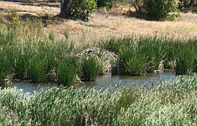
Beaver lodge on Southampton Creek
|
|
| Location | Solano County, California, USA |
| Nearest city | Benicia, California |
| Coordinates | 38°4′25″N 122°11′35″W / 38.07361°N 122.19306°WCoordinates: 38°4′25″N 122°11′35″W / 38.07361°N 122.19306°W |
| Area | 447 acres (181 ha) |
| Established | 1957 |
| Governing body | California Department of Parks and Recreation |
Benicia State Recreation Area is a state park unit of California, USA, protecting tidal wetland. It is located in Solano County 2 miles (3.2 km) west of downtown Benicia. The park covers 447 acres (181 ha) of marsh, grassy hillsides and rocky beaches along the narrowest portion of the Carquinez Strait. Southampton Creek and the tidal marsh front Southampton Bay, where the combined waters of the Sacramento and San Joaquin Rivers approach San Pablo Bay.
Don José de Cañizares — diarist on the 1769 overland Portola expedition and who sailed with Don Juan Manuel de Ayala on the San Carlos, the first ship to enter San Francisco Bay on August 5, 1775 — named the cove north and west of Benicia Puerto de las Asunta (Assumption Harbor in Spanish) because he discovered it on that feast day in 1775. The cove is noted as "J" on Cañizares' famous 1781 Map of San Francisco Bay. The present name, Southampton Bay, is for the Navy frigate Southampton, which Commodore Thomas ap Catesby Jones sailed, along with a small fleet, to the cove in 1849.
The sandstone point at Benicia SRA has been known as Rocky Point, Quarry Point and now Dillon Point. Stonecutter Patrick Dillon came to California from Tipperary, Ireland, during the 1849 California Gold Rush, settling in Benicia in 1851. General Vallejo leased Dillon the tidal flat at Southampton Bay and Rocky Point peninsula for a sandstone quarry. When the sandstone played out, the Dillon family and subsequent owners raised sheep and grapes until the State acquired the property in 1967.
...
Wikipedia


