Bayan-Ölgii Province
|
Bayan-Ölgii Province Баян-Өлгий аймаг ᠪᠠᠶ᠋ᠠᠨᠥᠯᠦᠭᠡᠢᠠᠶᠢᠮᠠᠭ |
|||
|---|---|---|---|
| Province | |||

|
|||
|
|||
 |
|||
| Coordinates: 48°18′N 89°30′E / 48.300°N 89.500°ECoordinates: 48°18′N 89°30′E / 48.300°N 89.500°E | |||
| Country | Mongolia | ||
| Established | 1940 | ||
| Capital | Ölgii | ||
| Area | |||
| • Total | 45,704.89 km2 (17,646.76 sq mi) | ||
| Population (2013) | |||
| • Total | 90,404 | ||
| • Density | 2.0/km2 (5.1/sq mi) | ||
| Time zone | UTC+7 | ||
| Area code(s) | +976 (0)142 | ||
| ISO 3166 code | MN-071 | ||
| Vehicle registration | БӨ_ | ||
| Website | www |
||
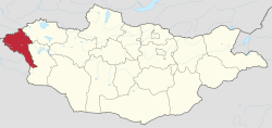
Bayan-Ölgii (Mongolian: Баян-Өлгий; Kazakh: Бай-Өлке, Rich cradle/region, alternately spelled Olgiy, Ulgii, etc.) is the westernmost of the 21 aimags (provinces) of Mongolia. The country's only Muslim and Kazakh-majority aimag, it was established in August 1940. Its capital is Ölgii.
The aimag is located in the extreme west of the country, and shares borders with both Russia and China. The border between the two neighbouring countries is very short here, though, and ends after about 40 km at the eastern end of Kazakhstan. Within Mongolia, the neighbouring aimags are Uvs in the north east and Khovd in the south east.
Bayan-Ölgii is the highest Mongolian aimag. For the most part it is located in the Mongolian Altay, at the transition point to the Russian Altay. About 10% of the territory are covered by forests, consisting primarily of Siberian Larch.
The Nairamdal Peak (also Friendship Peak, Chinese: Youyi Feng) of the Altai Tavan Bogd (five saints mountain) massif mountain marks the corner between the three neighbouring countries. About 2.5 km further south on the Mongolian-Chinese border, the Khüiten Peak is the highest point of Mongolia at a height of 4,374 m. The massif includes several glaciers, such as the 19 km Potanin Glacier, and is only accessible to experienced climbers with local guidance.
The Khovd River (the longest in the western Mongolian Great Lakes Depression) has its origin in this aimag. It is fed by the three lakes Khoton, Khurgan, and Dayan, and in turn feeds the lake Khar-Us Lake in the Khovd Aimag. The Tolbo Lake is a large saline lake about 50 km south of the aimag capital. It features clear and cold water on an elevation of 2,080 m.
...
Wikipedia


