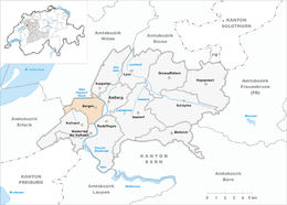
Bargen, Bern
| Bargen | ||
|---|---|---|
 |
||
|
||
| Coordinates: 47°2′N 7°15′E / 47.033°N 7.250°ECoordinates: 47°2′N 7°15′E / 47.033°N 7.250°E | ||
| Country | Switzerland | |
| Canton | Bern | |
| District | Seeland | |
| Area | ||
| • Total | 7.87 km2 (3.04 sq mi) | |
| Elevation | 448 m (1,470 ft) | |
| Population (Dec 2015) | ||
| • Total | 995 | |
| • Density | 130/km2 (330/sq mi) | |
| Postal code | 3282 | |
| SFOS number | 0302 | |
| Surrounded by | Niederried bei Kallnach, Kallnach, Siselen, Walperswil, Kappelen, Aarberg, Radelfingen. | |
| Website |
www SFSO statistics |
|
Bargen is a municipality in the Seeland administrative district in the canton of Bern in Switzerland.
Bargen is first mentioned in 1228 as Bargen. The earliest traces of humans are some scattered Bronze Age items at Bargenfeld and Neolithic and Hallstatt items in a gravel pit. It lies on the Roman road from Aventicum to Petinesca, of which some remains are still visible. There are some medieval ruins, which are probably from the cluniac priory's barge and bridge, between the old Aare bridge and village. In 1831-32 fortifications were built in the village to protect the strategic Aare river crossing.
It was part of the herrschaft of Aarberg and came with Aarberg under Bernese control in 1375.
The romanesque-gothic village church of St Mary was first mentioned in 1228. It the 14th century it was under the patronage of the lords of La Roche. In 1415 it came under the authority of Frienisberg Abbey. It was secularized in 1528 and was then owned by Bern. The church was remodeled in 1671-72.
The village has always depended on agriculture around the Aare river for much of its economy. The Aarberger Ship Canal (1645–63), the Hagneck Canal (1868–78) and the canal for the power station at Kallnach (1909–12) all changed the landscape around the village and opened up additional farming land. In 1990, over one-third of the jobs in the village were still in agriculture.
...
Wikipedia


