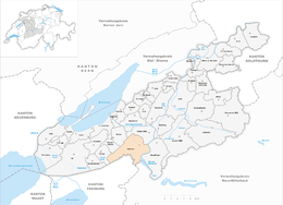
Kallnach
| Kallnach | ||
|---|---|---|
 |
||
|
||
| Coordinates: 47°1′N 7°14′E / 47.017°N 7.233°ECoordinates: 47°1′N 7°14′E / 47.017°N 7.233°E | ||
| Country | Switzerland | |
| Canton | Bern | |
| District | Seeland | |
| Area | ||
| • Total | 15.18 km2 (5.86 sq mi) | |
| Elevation | 445 m (1,460 ft) | |
| Population (Dec 2015) | ||
| • Total | 1,905 | |
| • Density | 130/km2 (330/sq mi) | |
| Postal code | 3283 | |
| SFOS number | 0304 | |
| Surrounded by | Bargen, Finsterhennen, Fräschels (FR), Kerzers (FR), Niederried bei Kallnach, Siselen, Treiten | |
| Website |
www SFSO statistics |
|
Kallnach (French: Chouchignies) is a municipality in the Seeland administrative district in the canton of Bern in Switzerland.
Kallnach is first mentioned in 1231 as apud Calnachon.
Kallnach was the site of a Bronze Age foundry as well as a small Roman era settlement or way station. The Roman road from Aventicum to Augusta Raurica or Vindonissa passed through Kallnach. A graveyard in Bergwegs indicates that the area was inhabited during the Early Middle Ages. In 1231 the Kyburg ministerialis (unfree knights in the service of a feudal overlord) family of Oltigen and the monasteries of Frauenkappelen, Frienisberg and Tedlingen all owned property in Kallnach. The ministerialis family of Schüpfen held the low justice right in Kallnach and Niederried. These properties and rights passed through a number of families until Bern bought the village in 1521-22 and incorporated it into the bailiwick of Aarberg.
The village church was built in 1608 over the ruins of an earlier, medieval chapel.
The village periodically flooded when the nearby Grosses Moos marsh flooded. The Jura water correction projects of 1868-91, 1933–36 and 1964–71 helped to end the flooding. The swampy land around the village was replaced with rich farm land that is now intensively farmed. In 1909-12 a hydroelectric power plant was built on the Aare river near Kallnach. The plant was expanded in 1978-80 and remains a major employer in the municipality. The Broyetal railroad (build in 1876) and the Lyss-Kallnach-Murten road allowed the village to grow. In the second half of the 20th century created the new housing developments of Krähenberg (1949), Rebe and Ammengasse (1970–80) were built to house the growing population.
...
Wikipedia


