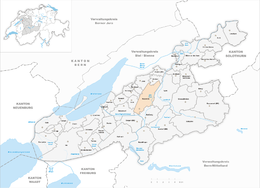
Kappelen
| Kappelen | ||
|---|---|---|

Kappelen village church and town hall
|
||
|
||
| Coordinates: 47°4′N 7°16′E / 47.067°N 7.267°ECoordinates: 47°4′N 7°16′E / 47.067°N 7.267°E | ||
| Country | Switzerland | |
| Canton | Bern | |
| District | Seeland | |
| Area | ||
| • Total | 10.96 km2 (4.23 sq mi) | |
| Elevation | 437 m (1,434 ft) | |
| Population (Dec 2015) | ||
| • Total | 1,350 | |
| • Density | 120/km2 (320/sq mi) | |
| Postal code | 3273 | |
| SFOS number | 0305 | |
| Surrounded by | Aarberg, Bargen, Bühl, Hermrigen, Jens, Lyss, Merzligen, Walperswil, Worben | |
| Website |
www SFSO statistics |
|
Kappelen (French: Chapelle) is a municipality in the Seeland administrative district in the canton of Bern in Switzerland.
Kappelen is first mentioned in 1228 as Capella.
The Roman road between Aventicum and Petinesca ran along the present day border of the municipality. During the Middle Ages, one of the major landowners in the village was the Counts of Neuchâtel-Nidau. The count granted Frienisberg Abbey land in Kappelen in 1225 and 1267. They gave Gottstatt Monastery patronage over the village church in 1247. The monastery held that right until 1528, when it was taken by Bern. Even after they granted land to the monasteries, the counts retained the right to collect a tithe from the village. The Counts of Neuchâtel-Aarberg originally had the right to hold the low court in the village. In 1367 this right went to Nidau and in 1377-79 it went to the city of Bern. At that time the village became part of the bailiwick of Aarberg. The neighboring village (and now part of the municipality) of Werdthof, the right to hold the low court in Werdthof and the chapel of St. Margaret (mentioned between 1231–1300, now demolished) were all given to Frienisberg Monastery in the 13th century.
The village church of St. Martin was first mentioned in 1228. It was destroyed in 1290 and rebuilt soon there after. It was rebuilt and expanded in 1682.
The Aare river flooded periodically, destroying or damaging the village, until the construction of the Hagneck Canal in 1868-78. After construction of the canal the swampy land around the village slowly drained, creating additional farm land. In the mid 19th century agriculture changed from growing produce and breeding horses to breeding livestock and dairy farming. The first cheese maker opened in Kappelen in 1868. Starting around 1900, the farms switched to growing sugar beets for the sugar factory in Aarberg. Agriculture has remained important in the local economy though a freight yard operated between 1954 and 1968. Between 1970-74 there was a cantonal Civil Defense Training Center in the village. In 1982-83 a regional office and maintenance depot of the cantonal construction department opened. While the village has no rail connection, it has been serviced by a bus from Biel and Aarberg since 1967 and the private Biel-Kappelen Airport.
...
Wikipedia


