Bühl bei Aarberg
| Bühl bei Aarberg | ||
|---|---|---|
 |
||
|
||
| Coordinates: 47°4′N 7°15′E / 47.067°N 7.250°ECoordinates: 47°4′N 7°15′E / 47.067°N 7.250°E | ||
| Country | Switzerland | |
| Canton | Bern | |
| District | Seeland | |
| Area | ||
| • Total | 2.98 km2 (1.15 sq mi) | |
| Elevation | 514 m (1,686 ft) | |
| Population (Dec 2015) | ||
| • Total | 423 | |
| • Density | 140/km2 (370/sq mi) | |
| Postal code | 3274 | |
| SFOS number | 0734 | |
| Surrounded by | Hermrigen, Kappelen, Walperswil, Epsach | |
| Website |
website missing SFSO statistics |
|
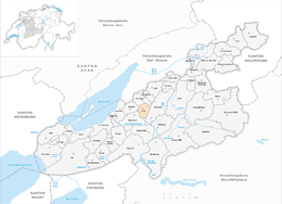
Bühl bei Aarberg (or simply Bühl) is a municipality in the Seeland administrative district in the canton of Bern in Switzerland.
Bühl is first mentioned in 1261 as Bule.
During the 13th century the land and rights over the village were owned by the Counts of Kyburg and the Kyburg Ministerialis (unfree knights in the service of a feudal overlord) families of Schüpfen, Mattstetten and Mörigen. It was part of the Herrschaft of Nidau, which was partly acquired by Bern in 1388 and fully acquired in 1393. Under Bernese control Bühl was combined with Walperswil to form a community that was known as the Upper County. Bühl was also part of the parish of Walperswil. It remained a small farming community for most of its history. While agriculture is still important in Bühl, over half of the residents commute to jobs in neighboring cities and towns. Additionally, even though it is an independent municipality, it shares much of the civic infrastructure with neighboring municipalities, such as the Zivilstandsamt (Vital records office), school and medical care.
Bühl has an area of 2.98 km2 (1.15 sq mi). As of 2012, a total of 2.65 km2 (1.02 sq mi) or 88.9% is used for agricultural purposes, while 0.1 km2 (0.039 sq mi) or 3.4% is forested. Of the rest of the land, 0.21 km2 (0.081 sq mi) or 7.0% is settled (buildings or roads) and 0.02 km2 (4.9 acres) or 0.7% is unproductive land.
During the same year, housing and buildings made up 4.7% and transportation infrastructure made up 2.3%. Out of the forested land, 1.3% of the total land area is heavily forested and 2.0% is covered with orchards or small clusters of trees. Of the agricultural land, 76.2% is used for growing crops and 11.1% is pastures, while 1.7% is used for orchards or vine crops.
...
Wikipedia


