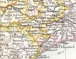
Baramba State
| Baramba State ବଡମ୍ବା ରାଜ୍ୟ |
|||||
| Princely State of British India | |||||
|
|||||
|
Flag |
|||||
| Baramba State in the Imperial Gazetteer of India | |||||
| History | |||||
| • | Established | 1305 | |||
| • | Accession to the Union of India | 1949 | |||
| Area | |||||
| • | 1892 | 368 km2(142 sq mi) | |||
| Population | |||||
| • | 1892 | 29,772 | |||
| Density | 80.9 /km2 (209.5 /sq mi) | ||||
| Today part of | Odisha, India | ||||
Flag
Baramba State (Odia: ବଡମ୍ବା ରାଜ୍ୟ) was one of the princely states of India during the period of the British Raj. The state was founded in 1305 and had its capital in Baramba town. Its last ruler signed the accession to the Indian Union on 1 January 1950. Baramba state was made part of Cuttack district of Orissa in 1948.
Baramba State was founded in 1305 when two villages, Sonkha and Mohuri, together with their land, were granted by the then King of Orissa, Kishore Narsingh, to the founder of the state, Hatakeshwar Rawat, in recognition for his courageous deeds. The original two villages have now merged into the present town of Sonkhameri. The last ruler of Baramba Princely State signed the accession to the Indian Union on 1 January 1948.
Rulers of Baramba bore the title 'Rawat' until 1874. The emblem of the Baramba royal family was a leopard.
Coordinates: 20°25′15″N 85°22′41″E / 20.42083°N 85.37806°E
...
Wikipedia


