Baram River
| Baram River | |
|---|---|

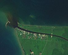
Mouth of Sungai Baram with black water plume
|
|
| Native name | Sungai Baram |
| Country | Malaysia |
| Basin features | |
| Main source | Borneo |
| River mouth | at Miri into South China Sea Sea level |
| Basin size | 22,100 km2 (8,533 sq mi) |
| Tributaries |
|
| Physical characteristics | |
| Length | 400 km (250 mi) |
The Baram River (Malay: Sungai Baram) is a river in Sarawak on the island of Borneo. The river originates in the Kelabit Highlands, a watershed demarcated by the Iran Mountains of East Kalimantan, which form a natural border with Sarawak. The river flows westwards through tropical rainforest to the South China Sea.
The Baram river basin has been part of Sarawak since it was ceded to the White Rajah of Sarawak by the then sultan of Brunei in 1882, an area of some 10,000 square miles (30,000 km2), for a perpetual annual payment of 6000 dollars.
The river is crossed not far from its mouth by the Miri-Baram Highway, Federal Route ![]() , on the Batang Baram Bridge opened in 2003. Some 100 km upstream lies the town of Marudi.
, on the Batang Baram Bridge opened in 2003. Some 100 km upstream lies the town of Marudi.
During the epoch or Mesolithic period about 10,000 years ago, there was a 5 degrees Celsius drop in the global temperature. At mountaintops, rainfall as snow and accumulated as huge icy sheets (including Mount Kinabalu), thus making a break in the global hydrological cycle. Due to lack of water discharge into the sea, there was a 120-meter drop of sea levels from the present time. The South China Sea dried up, exposing the Sunda Shelf and previous deep trenches became huge ancient rivers called the North Sunda River.
...
Wikipedia
