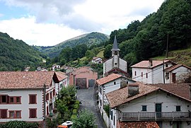
Banca, Pyrénées-Atlantiques
| Banca | |
|---|---|
| Commune | |

A general view of Banca
|
|
| Coordinates: 43°07′39″N 1°22′23″W / 43.1275°N 1.3731°WCoordinates: 43°07′39″N 1°22′23″W / 43.1275°N 1.3731°W | |
| Country | France |
| Region | Nouvelle-Aquitaine |
| Department | Pyrénées-Atlantiques |
| Arrondissement | Bayonne |
| Canton | Montagne Basque |
| Intercommunality | CA Pays Basque |
| Government | |
| • Mayor (2008–2020) | Michel Oçafrain |
| Area1 | 49.60 km2 (19.15 sq mi) |
| Population (2010)2 | 335 |
| • Density | 6.8/km2 (17/sq mi) |
| Time zone | CET (UTC+1) |
| • Summer (DST) | CEST (UTC+2) |
| INSEE/Postal code | 64092 /64430 |
| Elevation | 231–1,275 m (758–4,183 ft) (avg. 522 m or 1,713 ft) |
|
1 French Land Register data, which excludes lakes, ponds, glaciers > 1 km² (0.386 sq mi or 247 acres) and river estuaries. 2Population without double counting: residents of multiple communes (e.g., students and military personnel) only counted once. |
|
1 French Land Register data, which excludes lakes, ponds, glaciers > 1 km² (0.386 sq mi or 247 acres) and river estuaries.
Banca (Basque: Banka) is a commune of the Pyrénées-Atlantiques department in the Nouvelle-Aquitaine region of south-western France in the former province of Lower Navarre.
Banca is part of Pays Quint (Kintoa in Basque or Quinto Real in Spanish), an area of pasture area which belongs to Spain but is cultivated by French farmers.
The inhabitants of the commune are known as Bankars.
Banca is located in the Aldudes valley on the banks of the Nive des Aldudes some 15 km south-west of Saint-Jean-Pied-de-Port. The western and eastern borders of the commune are the national frontier between France and Spain. Access to the commune is by the D948 road from Saint-Étienne-de-Baïgorry in the north which passes through the commune and the village and continues south-west to Aldudes. There are no crossing points in the commune to Spain. The commune is mainly rugged alpine pastures.
The Nive des Aldudes flows from Aldudes in the south-west, gathering tributaries such as the Antchignoko Erreka, the Ruisseau d'Hayra, the Latcharrako Erreka, and the Belechiko Erreka on the northern border, and continues north-east to join the Nive south of Saint-Martin-d'Arrossa. The Ruisseau d'Hayra rises in the south of the commune and flows north gathering tributaries such as the Lehaltzarteko Erreka, the Caminarteko Erreka, and the Legarzuko Erreka to join the Nive des Aldudes near the village.
...
Wikipedia


