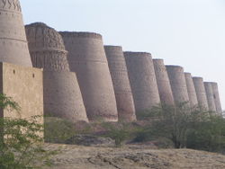
Bahawalpur District
|
Bahawalpur بہاول پور |
|
|---|---|
| District | |

|
|
| Country | Pakistan |
| Province | Punjab |
| Headquarters | Bahawalpur |
| Government | |
| • Members of National Assembly |
Syed Ali Hassan Gilani (NA-183) Najibuddin Awaisi (NA-184) Muhammad Baligh Ur Rehman (NA-185) Riaz Hussain Pirzada (NA-186) Tariq Bashir Cheema (NA-187) |
| Area | |
| • Total | 24,830 km2 (9,590 sq mi) |
| Population (1998) | |
| • Total | 2,433,091 |
| Time zone | PKT (UTC+5) |
| Number of Tehsils | 5 |
| Tehsils |
Bahawalpur Ahmedpur Sharqia Hasilpur Khairpur Tamewali Yazman |
| Languages | Saraiki, Punjabi and Urdu |
Bahawalpur District (Punjabi,Urdu: ضلع بہاول پور) is one of the districts of Punjab, Pakistan. Its capital is Bahawalpur city. According to the 1998 Census of Pakistan it had a population of 2,433,091 of which 27.01% were urban Bahawalpur district covers 24,830 km². Approximately two-thirds of the district (16,000 km²) is covered by the Cholistan Desert, which extends into the Thar Desert of India. The district is a major producer of cotton.
It is located in the south of the Punjab province, Bahawalpur district is bordered by India to its south and south east, Bahawalnagar to its north east, Vehari, Lodhran and Multan to its north, Rahimyar Khan to its west and Muzaffargarh to its north west.
The district is administratively divided into five tehsils and 107 Union Councils:
According to the 1998 census, the most widely spoken first language in the district was Saraiki, accounting for 64.3% of the population, followed by Punjabi with 28.4% and Urdu with 5.5%.
In 711 A.D. the various parts of Punjab and whole Sindh came under the Arab rule when Muhammad Bin Qasim had conquered Sindh, Multan and surrounding areas of Shorkot. The region came securely under Umayyad Caliphate. The tribes known as Arain in the region are the decadents of those Arab soldiers who accompanied Muhammad Bin Qasim.
...
Wikipedia
