Badakshan Province
|
Badakhshan Province ولایت بدخشان |
|
|---|---|
| Province | |

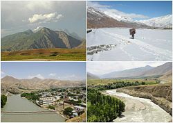
Different districts of Badakhshan Province
|
|
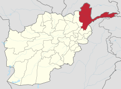
 Map of Afghanistan with Badakhshan highlighted |
|
| Coordinates: 38°0′N 71°0′E / 38.000°N 71.000°ECoordinates: 38°0′N 71°0′E / 38.000°N 71.000°E | |
| Country |
|
| Capital | Fayzabad |
| Government | |
| • Governor | Ahmad Faisal Begzad |
| Area | |
| • Total | 44,059 km2 (17,011 sq mi) |
| Population (2012) | |
| • Total | 904,700 |
| • Density | 21/km2 (53/sq mi) |
| Time zone | UTC+4:30 |
| ISO 3166 code | AF-BDS |
| Main languages | Persian, Khowar, Pashto, Kyrgyz, Shughni, Munji, Ishkashimi, Wakhi |
Badakhshan Province (Pashto: بدخشان ولایت Badaxšān wilāyat and Persian: ولایت بدخشان Velâyate Badaxšân) is one of the 34 provinces of Afghanistan, located in the farthest northeastern part of the country between Tajikistan and northern Pakistan. It shares a 56.5 miles (91 km) border with China.
It is part of a broader historical Badakhshan region. The province contains 22 to 28 districts, over 1,200 villages, and approximately 904,700 people.Feyzabad serves as the provincial capital.
Badakhshan is primarily bordered by Gorno-Badakhshan Autonomous Province and Khatlon Province in Tajikistan to the north and east. In the east of the province a long spur called the Wakhan Corridor extends above northern Pakistan's Chitral and Northern Areas to a border with China. The province has a total area of 44,059 square kilometres (17,011 sq mi), most of which is occupied by the Hindu Kush and Pamir mountain ranges.
Badakhshan was a stopover on the ancient Silk Road trading path, and China has shown great interest in the province after the fall of the Taliban, helping to reconstruct roads and infrastructure.
According to the World Wildlife Fund, Badakhshan contains temperate grasslands, savannas, and shrublands, as well as Gissaro-Alai open woodlands along the Pamir River. Common plants found in these areas include pistachio, almond, walnut, apple, juniper, and sagebrush.
...
Wikipedia
