Austrian Alps
| Central Eastern Alps | |
|---|---|

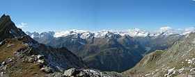
Venediger Group of the High Tauern
|
|
| Highest point | |
| Peak | Piz Bernina |
| Elevation | 4,049 m (13,284 ft) |
| Coordinates | 46°22′56.6″N 9°54′29.2″E / 46.382389°N 9.908111°ECoordinates: 46°22′56.6″N 9°54′29.2″E / 46.382389°N 9.908111°E |
| Geography | |

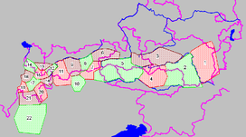
Central Eastern Alps ranges (purple lines showing international borders and borders of Austrian states):
Prealps East of the Mur (1) * Lavanttal Alps (2) * Low Tauern (3) * Gurktal Alps (4) * High Tauern (5) * Kitzbühel Alps (6) * Zillertal Alps (7) * Tux Alps (8) * Stubai Alps (9) * Sarntal Alps (10) * Ötztal Alps (11) * Samnaun Alps (12) * Verwall Alps (13) * Rätikon (14) * Silvretta Alps (15) * Sesvenna (16) * Albula Alps (17) * Plessur Alps (18) * Oberhalbstein Alps (19) * Livigno Alps (20) * Bernina (21) * Bergamo Alps (22) |
|
| Countries | |
| States | |
| Parent range | Eastern Alps |
| Geology | |
| Orogeny | Alpine |
| Age of rock | Mesozoic and Tertiary |
| Type of rock | Gneiss and Slate |
The Central Eastern Alps (German: Zentralalpen or Zentrale Ostalpen), also referred to as Austrian Central Alps (German: Österreichische Zentralalpen) or just Central Alps comprise the main chain of the Eastern Alps in Austria and the adjacent regions of Switzerland, Liechtenstein, Italy and Slovenia.
The term "Central Alps" is very common in the Geography of Austria as one of the seven major landscape regions of the country. "Central Eastern Alps" is usually used in connection with the Alpine Club classification of the Eastern Alps (Alpenvereinseinteilung, AVE). The Central Alps form the eastern part of the Alpine divide, its central chain of mountains, as well as those ranges that extend or accompany it to the north and south.
The highest mountain in the Austrian Central Alps is Grossglockner at 3,798 metres (12,461 ft).
The Central Alps have the highest peaks of the Eastern Alps, and are located between the Northern Limestone Alps and the Southern Limestone Alps, from which they differ in geological composition.
The term "Central Eastern Alps" may also be used more broadly to refer to a larger area of the Eastern Alps, mainly located in Austria, extending from the foot of the Bergamasque Alps at Lake Como and the Bernina Range in the Graubünden canton of eastern Switzerland along the Liechtenstein shore of the Rhine in the west as far as to the lower promontories east of the Mur river including the Hochwechsel in Austrian Styria. The valleys of the rivers Inn, Salzach and Enns mark their northern boundary, the Drau river (roughly corresponding to the Periadriatic Seam) their southern border. In the proposed SOIUSA system, the "Central-eastern Alps" include the Rhaetian Alps, of which the Bernina Range includes the 4,049-meter Piz Bernina in Switzerland, the easternmost 4,000 meter peak of the Alps. In the AVE system, however, the full list of mountain groups in the Alpine Club classification of the Eastern Alps includes the Bernina and neighboring ranges within the Western Limestone Alps, not the Central Eastern Alps as the Alpine Club defines them.
...
Wikipedia
