Eastern Alps
| Eastern Alps | |
|---|---|

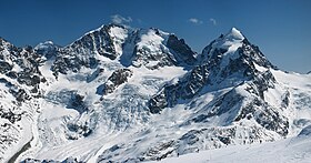
Piz Bernina (centre-left) with the Biancograt to the left, Piz Scerscen (centre-right) and Piz Roseg (right), seen from Piz Corvatsch
|
|
| Highest point | |
| Peak | Piz Bernina |
| Elevation | 4,049 m (13,284 ft) |
| Coordinates | 46°22′56.6″N 9°54′29.2″E / 46.382389°N 9.908111°E |
| Dimensions | |
| Area | 130,000 km2 (50,000 sq mi) |
| Geography | |
| Countries |
List
|
| Range coordinates | 46°35′N 12°14′E / 46.58°N 12.23°ECoordinates: 46°35′N 12°14′E / 46.58°N 12.23°E |
| Parent range | Alps |
| Borders on |
List
|
| Geology | |
| Orogeny | Alpine orogeny |
Eastern Alps is the name given to the eastern half of the Alps, usually defined as the area east of a line from Lake Constance and the Alpine Rhine valley up to the Splügen Pass at the Alpine divide and down the Liro River to Lake Como in the south. The peaks and mountain passes are lower compared to the Western Alps, while the range itself is broader and less arched.
The Eastern Alps include the eastern parts of Switzerland (mainly Graubünden), all of Liechtenstein, and most of Austria from Vorarlberg to the east, as well as parts of extreme Southern Germany (Upper Bavaria), northwestern Italy (Lombardy), northeastern Italy (Trentino-Alto Adige/Südtirol, Veneto and Friuli-Venezia Giulia) and a good portion of northern Slovenia (Upper Carniola and Lower Styria). In the south the range is bound by the Italian Padan Plain; in the north the valley of the Danube river separates it from the Bohemian Massif. The easternmost spur is formed by the Vienna Woods range, with the Leopoldsberg overlooking the Danube and the Vienna basin, which is the transition zone to the arch of the Carpathian Mountains.
...
Wikipedia

