Niedere Tauern
| Lower Tauern | |
|---|---|
| Niedere Tauern | |

Hochgolling (2,862 m)
|
|
| Highest point | |
| Peak | Hochgolling |
| Elevation | 2,863 m (9,393 ft) |
| Coordinates | 47°16′0″N 13°45′42″E / 47.26667°N 13.76167°E |
| Geography | |
| Country | Austria |
| States | Salzburg and Styria |
| Range coordinates | 47°18′N 14°0′E / 47.300°N 14.000°ECoordinates: 47°18′N 14°0′E / 47.300°N 14.000°E |
| Parent range | Central Eastern Alps |
| Borders on |
List
|
| Geology | |
| Orogeny | Alpine orogeny |
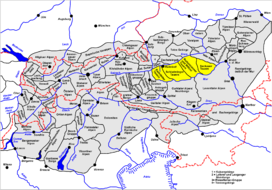
The Lower Tauern or Niedere Tauern (Slovene: Nizke Ture) are a mountain range of the Central Eastern Alps, in the Austrian states of Salzburg and Styria.
For the etymology of the name, see Tauern.
The range forms a part of the main chain of the Alps. The highest peak of the Lower Tauern is the Hochgolling, part of the Schladming Tauern, at 2,863 m (9,393 ft).
Important mountain pass roads include Radstädter Tauern Pass (1,738 m (5,702 ft)), Sölk Pass (1,788 m (5,866 ft)), and Triebener Tauern Pass (1,274 m (4,180 ft)). The range is also crossed by the Tauern Autobahn (A10) through the Tauern Road Tunnel.
In the west and south the Murtörl mountain pass and the River Mur separate them from the Hohe Tauern mountain range, while in the east and north the River Enns and the Schober Pass marks the border to the Northern Limestone Alps.
According to the Alpine Club classification of the Eastern Alps, the Lower Tauern may be divided into four subgroups (from west to east):
...
Wikipedia

