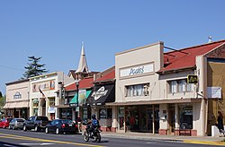
Arroyo Grande, California
| Arroyo Grande, California | ||
|---|---|---|
| City | ||

The Arroyo Grande Village in 2012 seen from Branch Street.
|
||
|
||
 Location in San Luis Obispo County and the state of California |
||
| Location in the United States | ||
| Coordinates: 35°7′15″N 120°35′12″W / 35.12083°N 120.58667°WCoordinates: 35°7′15″N 120°35′12″W / 35.12083°N 120.58667°W | ||
| Country |
|
|
| State |
|
|
| County |
|
|
| Incorporated | July 10, 1911 | |
| Area | ||
| • Total | 5.835 sq mi (15.113 km2) | |
| • Land | 5.835 sq mi (15.113 km2) | |
| • Water | 0 sq mi (0 km2) 0% | |
| Elevation | 118 ft (36 m) | |
| Population (2013 Estimate) | ||
| • Total | 17,716 | |
| • Density | 3,000/sq mi (1,200/km2) | |
| Time zone | Pacific (PST) (UTC-8) | |
| • Summer (DST) | PDT (UTC-7) | |
| ZIP codes | 93420-93421 | |
| Area code | 805 | |
| FIPS code | 06-02868 | |
| GNIS feature IDs | 1660271, 2409734 | |
| Website | www |
|
Arroyo Grande is a city in San Luis Obispo County, California, United States. The population was 17,716 at the 2013 census.
The earliest inhabitants of the Arroyo Grande valley were Chumash Indians, who conducted extensive trade with other Native American tribes at considerable distance.
The first Europeans to see this stretch of coast were the crew of Portuguese explorer Juan Rodríguez Cabrillo, working in the service of Spain. The Spanish Portolà expedition was the first European visit by land, passing through the area on September 4, 1769. When Mission San Luis Obispo de Tolosa was established nearby, the Portolà trail became part of the road connecting the 21 Spanish missions (today called El Camino Real). Later, agricultural activities expanded into the area. The Arroyo Grande valley was found to have particularly fertile ground, and was given the name meaning "wide riverbed" in Spanish.
Francis Ziba Branch, originally from New York, saw the area on a hunting expedition during the period when California was part of Mexico. Branch married María Manuela Carlón, and this marriage entitled Branch to file claim for a Mexican land grant. In 1836 he and his wife and baby son moved onto Rancho Santa Manuela. They were managing a successful cattle ranching operation when California became a U.S. territory, and then a U.S. State. But some years later they suffered financial difficulties during a drought when many cattle died. They sold off smaller parcels of land to settlers.
...
Wikipedia


