Ardennes Forest
| Ardennes | |
|---|---|

Landscape of Frahan inside the bend of the Semois River
|
|
 |
|
| Location |
Wallonia, Belgium; Oesling, Luxembourg; Ardennes department and Grand Est region, France |
| Coordinates | 50°15′N 5°40′E / 50.250°N 5.667°ECoordinates: 50°15′N 5°40′E / 50.250°N 5.667°E |
| Area | 11,200 km2 (4,300 sq mi) |
| Governing body | Parc National de Champagne/Ardennes Parc National de Furfooz |
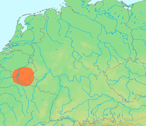
The Ardennes (/ɑːrˈdɛn/; French: L'Ardenne; Walloon: L'Årdene; Luxembourgish: Ardennen; also known as Ardennes Forest) is a region of extensive forests, rough terrain, rolling hills and ridges formed by the geological features of the Ardennes mountain range and the Moselle and Meuse River basins. Geologically, the range is a western extension of the Eifel and both were raised during the Givetian age of the Devonian (387.7 to 382.7 million years ago) as were several other named ranges of the same greater range.
Primarily in Belgium and Luxembourg, but stretching into Germany and France (lending its name to the Ardennes department and the former Champagne-Ardenne region), and geologically into the Eifel—the eastern extension of the Ardennes Forest into Bitburg-Prüm, Germany, most of the Ardennes proper consists of southeastern Wallonia, the southern and more rural part of the Kingdom of Belgium (away from the coastal plain but encompassing over half of the kingdom's total area). The eastern part of the Ardennes forms the northernmost third of the Grand Duchy of Luxembourg, also called "Oesling" (Luxembourgish: Éislek), and on the southeast the Eifel region continues into Rhineland-Palatinate (German state).
...
Wikipedia
