Eifel
| Eifel | |
|---|---|
| Highest point | |
| Peak | Hohe Acht |
| Elevation | 747 m (2,451 ft) |
| Dimensions | |
| Length | 100 km (62 mi) |
| Area | 5,300 km2 (2,000 sq mi) |
| Geography | |
| Countries | Germany, Belgium and Luxembourg |
| States | Rhineland-Palatinate and North Rhine-Westphalia |
| Range coordinates | 50°23′N 6°52′E / 50.39°N 6.87°ECoordinates: 50°23′N 6°52′E / 50.39°N 6.87°E |
| Parent range | Rhenish Slate Mountains |
| Geology | |
| Orogeny | low mountains |
| Type of rock | slate, limestone, quartzite, sandstone, basalt |
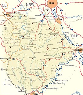
The Eifel (Luxembourgish: Äifel) is a low mountain range in western Germany and eastern Belgium. It occupies parts of southwestern North Rhine-Westphalia, northwestern Rhineland-Palatinate and the south of the German-speaking Community of Belgium.
The Eifel is part of the Rhenish Massif; within its northern portions lies the Eifel National Park.
The Eifel lies between the cities of Aachen to the north, Trier to the south and Koblenz to the east. It descends in the northeast along a line from Aachen via Düren to Bonn into the Lower Rhine Bay. In the east and south it is bounded by the valleys of the Rhine and the Moselle. To the west it transitions in Belgium and Luxembourg into the geologically related Ardennes and the Luxembourg Ösling. In the north it is limited by the Jülich-Zülpicher Börde. Within Germany it lies within the states of Rhineland-Palatinate and North Rhine-Westphalia; in BeNeLux the area of Eupen, St. Vith and Luxembourg. Its highest point is the volcanic cone of the Hohe Acht (746.9 m). Originally the Carolingian Eifelgau only covered the smaller region roughly around the sources of the rivers Ahr, Kyll, Urft and Erft. Its name was more recently transferred to the entire region.
...
Wikipedia

