Hohe Acht
| Hohe Acht | |
|---|---|

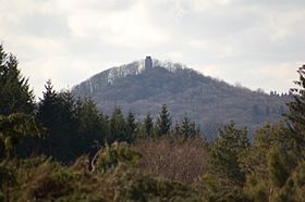
The prominent peak of the Hohe Acht seen from the summit plateau of the Raßberg
|
|
| Highest point | |
| Elevation | 746.9 m above sea level (NHN) (2,450 ft) |
| Prominence | 525 metres (1,722 ft) |
| Isolation | 63 kilometres (39 mi) |
| Coordinates | 50°23′09″N 7°00′40″E / 50.38583°N 7.01111°ECoordinates: 50°23′09″N 7°00′40″E / 50.38583°N 7.01111°E |
| Geography | |
|
|
|
| Parent range | Eifel |
At 746.9 m above sea level (NHN), the Hohe Acht is the highest mountain in the Eifel mountains of Germany. It is located on the boundary between the districts of Ahrweiler and Mayen-Koblenz in Rhineland-Palatinate.
The Hohe Acht is located in the High Eifel east of Adenau. The mountain is a tertiary volcano, whose cone is composed of Lower Devonian rock and whose summit is made of basalt.
In 1908/09 the Emperor William Tower (Kaiser-Wilhelm-Turm) was erected on the Hohe Acht. The reason for the construction of this stone observation tower, based on plans by the architect, Freiherr von Tettau, Berlin, was the silver wedding of Emperor William II and Empress Augusta Victoria as well as the commemoration of Emperor William I
The tower is 16.30 metres (53.5 ft) high and its walls are one metre thick at ground level. The work was carried out by master masons, Karl and Johannes Leidinger, from Adenau using local stone. The cost of construction was 18,000 marks. The tower has been a protected monument since 1987.
The Emperor William Tower offers a superb view across the whole Eifel (including the mountains of Scharteberg, Döhmberg, Michelsberg, Hochthürmerberg, Schöneberg, the nearby Nürburg Castle and Hochkelberg), as well as the Siebengebirge and its Großer Ölberg and, in conditions of good visibility, as far as the Westerwald, the Taunus, the Hunsrück and the Lower Rhine.
...
Wikipedia

