Aragatsotn Province
|
Aragatsotn Արագածոտն |
|
|---|---|
| Province | |
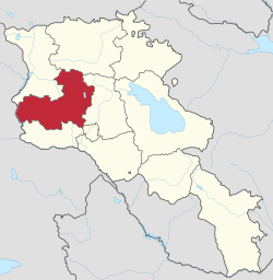
 Location of Aragatsotn within Armenia |
|
| Coordinates: 40°25′N 44°10′E / 40.417°N 44.167°ECoordinates: 40°25′N 44°10′E / 40.417°N 44.167°E | |
| Country | Armenia |
|
Capital and largest city |
Ashtarak |
| Government | |
| • Governor | Sargis Sahakyan |
| Area | |
| • Total | 2,756 km2 (1,064 sq mi) |
| Area rank | 5th |
| Population (2011) | |
| • Total | 132,925 |
| • Rank | 9th |
| Time zone | AMT (UTC+04) |
| Postal code | 0201-0514 |
| ISO 3166 code | AM.AG |
| FIPS 10-4 | AM01 |
| Website | Official website |
Aragatsotn (Armenian: , Armenian pronunciation: [ɑɾɑɡɑˈt͡sɔtən]) is a province (marz) of Armenia. It is located at the western part of the country. The capital and largest city of the province is the town of Ashtarak. The National Statistical Service of the Republic of Armenia (ARMSTAT) reported its population was 132,925 in the 2011 census.
Literally meaning "the foot of Aragats" (the highest mountain of the Republic of Armenia), it is named after the Aragatsotn canton of the historic Ayrarat province of Ancient Armenia, ruled by the Amatuni noble family under the reign of the Arsacid Dynasty.
Aragatsotn Province occupies the northwestern part of Armenia and covers an area of 2,756 km² (9.3% of total area of Armenia). It has domestic borders with Shirak Province from the north, Lori Province from the northeast, Kotayk Province from the east, Armavir Province from the south and the city of Yerevan from the southwest. The Akhurian River at the west separates Aragatsotn from the Kars Province of Turkey.
Historically, the current territory of the province mainly occupies parts the Aragatsotn, Nig and Shirak cantons of Ayrarat province of Ancient Armenia.
...
Wikipedia
