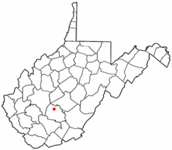
Ansted, West Virginia
| Ansted, West Virginia | |
|---|---|
| Town | |
 Location of Ansted, West Virginia |
|
| Coordinates: 38°8′10″N 81°6′7″W / 38.13611°N 81.10194°WCoordinates: 38°8′10″N 81°6′7″W / 38.13611°N 81.10194°W | |
| Country | United States |
| State | West Virginia |
| County | Fayette |
| Government | |
| • Mayor | R.A. Hobbs |
| Area | |
| • Total | 1.67 sq mi (4.33 km2) |
| • Land | 1.66 sq mi (4.30 km2) |
| • Water | 0.01 sq mi (0.03 km2) |
| Elevation | 1,319 ft (402 m) |
| Population (2010) | |
| • Total | 1,404 |
| • Estimate (2012) | 1,406 |
| • Density | 845.8/sq mi (326.6/km2) |
| Time zone | Eastern (EST) (UTC-5) |
| • Summer (DST) | EDT (UTC-4) |
| ZIP code | 25812 |
| Area code(s) | 304 |
| FIPS code | 54-01996 |
| GNIS feature ID | 1534968 |
Ansted is a town in Fayette County in the U.S. state of West Virginia. The population was 1,404 at the 2010 census. It is situated on high bluffs along U.S. Route 60 on a portion of the Midland Trail a National Scenic Byway near Hawk's Nest overlooking the New River far below.
The area of what is now southern West Virginia was long a hunting ground for nomadic tribes of Native-Americans before the arrival of Europeans in the 17th century. Around 1790, the area now known as Ansted was settled by a group of Baptists who did not hold legal title to the land. These people were known as "squatters," and built the Hopewell Baptist Church nearby. In 1792, a 400-acre (1.6 km²) tract of land in the area was patented to Charles Skaggs.
Named in honor of the Marquis de la Fayette, a major hero of the American Revolutionary War, Fayette County, Virginia was created in 1831. The first county court was held that same year at Miles Manser's general store which stood nearby Ansted's current location along the James River and Kanawha Turnpike, an early roadway built to connect the canals on the James and Kanawha Rivers. The area was known at that time as Mountain Cove. At various times, it has also been known as Woodville, New Haven, and Westlake.
During the American Civil War, the area of Fayette County was a focus of both Union and Confederate efforts. The burning of Gauley Bridge was a spectacular event long-remembered in the community. During the winter of 1861-62, the Chicago Gray Dragoons of the Union Army were based at the Halfway House (Tyree Tavern) in what is now Ansted. At this time, Confederate General Robert E. Lee maintained headquarters on nearby Sewell Mountain. The Chicago Dragoons had a strong religious orientation and ties to the Young Men's Christian Association (YMCA) of Chicago. Many Union troops felt they were fighting the moral issue of slavery while although many citizens of Fayette County were more sympathetic to the "states rights" issues of the Confederacy. The area became part of the new State of West Virginia when it was formed in 1863 as part of the Union. Local lore speaks of romances between the local girls and the young soldiers from Illinois. Some of these young couples married and built homes and raised their families in the Mountain State at the end of hostilities. It is also the burial site of Stonewall Jackson's mother, Julia Neale Jackson in Westlake Cemetery.
...
Wikipedia
