Amargosa Desert
| Amargosa Desert | |
|
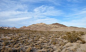
Amargosa Desert near the Bullfrog Hills
|
|
| Name origin: Amargosa River | |
| Country | United States |
|---|---|
| State | Nevada and California |
| Region | Great Basin |
| County | Nye and Inyo |
| Borders on | west: Funeral Mountains & Yucca Mountain east: Nellis Air Force Range |
| Parts | Franklin Lake Playa |
| River | Amargosa |
| Elevation | 2,411 ft (735 m) |
| Area | 2,600 sq mi (6,734 km2) including: 1981 sq mi of Amargosa River Basin 600 sq mi of Amargosa Valley |
| Geology | Crater Flat |
| Timezone | Pacific (UTC-8) |
| - summer (DST) | PDT (UTC-7) |
|
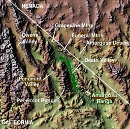
The Amargosa Desert is near Death Valley
|
|
The Amargosa Desert is located in Nye County in western Nevada, United States, along the California–Nevada border, comprising the northeastern portion of the geographic Amargosa Valley, north of the Ash Meadows National Wildlife Refuge
The desert is named after the Amargosa River, so-named for the Spanish word for bitter because of the bitter taste of the water.
The Amargosa Desert lies at an elevation of about 2,600 to 2,750 feet (790 to 840 m), and includes Crater Flat and the community of Amargosa Valley, Nevada, (formerly Lathrop Wells), which lies at the southern end of the desert.
The desert lies between the Funeral Mountains and Death Valley to the west, and Yucca Mountain and the Nellis Air Force Range to the east.
The Amargosa Desert is an arid desert habitat and an ecotone between the northern Great Basin and southern Mojave Desert ecosystems and biogeography regions. The seasonal Amargosa River course runs through the desert, with the rare Shoshone pupfish in nearby Amargosa Pupfish Station of the Desert National Wildlife Refuge Complex.
...
Wikipedia


