Alighidir
|
Aligider علي غدير Adi Ghider, Ali-Guider, Alighedir |
|
|---|---|
| Location in Eritrea | |
| Coordinates: 15°07′N 36°29′E / 15.117°N 36.483°E | |
| Country |
|
| Region | Gash-Barka |
| District | Teseney District |
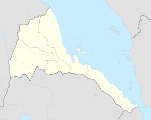
Aligider (Arabic: علي غدير) is located ten kilometers to the west of Teseney in the country of Eritrea. It is part of the Teseney sub-zone and has a diverse population. It is considered the last settlement in Eritrea before reaching the Sudanese Border and is located in the lowlands.
Agriculture, livestock raising and trade are very important to the economy of the area. Aligider has access to potable water from both the Gash River and underground water resources. Processes of irrigation have created an artificial marsh near the Gash River which provides a large habitat for many bird species.
Aligider was once an Italian frontier village. Aligider was an agricultural area, growing cotton and other crops, and managed by the Societa Impresse Africana (SIA). SIA helped develop Aligider into a company town, housing tenant farmers and other workers on the plantation. A school and clinic were set up and by the 1950s, the plantation employed 2,000 Eritreans, 15 Italians and "provided a residence for another 12,000 part time workers and family members."
A well-known Italian business that was established for many years in Aligider was the Barattolo cotton plantation which was established in 1965 by Roberto Barattolo in a purchase from SIA. This acquisition from the SIA allowed Barattolo to export knitwear to both Europe and the Middle East.
Aligider received significant damage from the sacking by Ethiopian forces. Many of the Italian artifacts left from its time as a frontier village were destroyed in 2001 through Ethiopian military actions.
Coordinates: 15°07′00″N 36°29′00″E / 15.11667°N 36.48333°E
...
Wikipedia

