1998 Pacific typhoon season
| 1998 Pacific typhoon season |
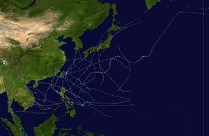
Season summary map
|
| Seasonal boundaries |
| First system formed |
May 28, 1998 |
| Last system dissipated |
December 21, 1998 |
| Strongest storm |
|
| Name |
Zeb |
| • Maximum winds |
205 km/h (125 mph) |
| • Lowest pressure |
900 hPa (mbar) |
| Seasonal statistics |
| Total depressions |
23 official, 5 unofficial |
| Total storms |
15 official, 3 unofficial |
| Typhoons |
8 official, 1 unofficial |
| Super typhoons |
3 unofficial |
| Total fatalities |
≥691 |
| Total damage |
~ $4.8 billion (1998 USD) |
| Related articles |
|
|
Pacific typhoon seasons
1996, 1997, 1998, 1999, 2000
|
| Tropical depression (JMA) |
| Tropical depression (SSHWS) |
|
|
| Duration |
July 7 – July 11 |
| Peak intensity |
55 km/h (35 mph) (10-min) 1002 hPa (mbar) |
| Tropical storm (JMA) |
| Tropical storm (SSHWS) |
|
|
| Duration |
July 8 – July 10 |
| Peak intensity |
65 km/h (40 mph) (10-min) 998 hPa (mbar) |
| Tropical depression (JMA) |
| Tropical storm (SSHWS) |
|
|
| Duration |
July 24 – July 26 |
| Peak intensity |
55 km/h (35 mph) (10-min) 1004 hPa (mbar) |
| Typhoon (JMA) |
| Category 3 typhoon (SSHWS) |
|
|
| Duration |
August 2 – August 5 |
| Peak intensity |
120 km/h (75 mph) (10-min) 970 hPa (mbar) |
| Severe tropical storm (JMA) |
| Tropical storm (SSHWS) |
|
|
| Duration |
August 6 – August 11 |
| Peak intensity |
95 km/h (60 mph) (10-min) 985 hPa (mbar) |
| Typhoon (JMA) |
| Category 4 typhoon (SSHWS) |
|
|
| Duration |
August 22 – September 9 |
| Peak intensity |
140 km/h (85 mph) (10-min) 955 hPa (mbar) |
| Tropical depression (JMA) |
| Tropical depression (SSHWS) |
|
|
| Duration |
September 1 – September 5 |
| Peak intensity |
55 km/h (35 mph) (10-min) 1002 hPa (mbar) |
| Severe tropical storm (JMA) |
| Category 1 typhoon (SSHWS) |
|
|
| Duration |
September 12 – September 16 |
| Peak intensity |
110 km/h (70 mph) (10-min) 965 hPa (mbar) |
| Tropical depression (JMA) |
| Tropical depression (SSHWS) |
|
|
| Duration |
September 13 – September 14 |
| Peak intensity |
55 km/h (35 mph) (10-min) 998 hPa (mbar) |
The 1998 Pacific typhoon season was one of the least active seasons on record, behind 2010. These dates conventionally delimit the period of each year when most tropical cyclones form in the northwestern Pacific Ocean.
The scope of this article is limited to the Pacific Ocean, north of the equator and west of the international date line. Storms that form east of the date line and north of the equator are called hurricanes; see 1998 Pacific hurricane season. Tropical Storms formed in the entire west Pacific basin were assigned a name by the Joint Typhoon Warning Center. Tropical depressions in this basin have the "W" suffix added to their number. Tropical depressions that enter or form in the Philippine area of responsibility are assigned a name by the Philippine Atmospheric, Geophysical and Astronomical Services Administration or PAGASA. This can often result in the same storm having two names.
The 1998 season was very weak compared to the 1997 season; this was due to the strong El Niño in the previous season. During the 1998 season, a total of 28 tropical depressions developed across the western Pacific basin. Of those 28 depressions, a total of 18 strengthened into tropical storms of which 9 further intensified into typhoons. The first tropical cyclone developed on May 28, marking the fourth latest start to any Pacific typhoon season on record, and the last one dissipated on December 22. The Philippine region also set a record: with only eleven storms forming or moving into its area of responsibility, PAGASA had its quietest season as of 2006.
The second tropical depression of the season developed out of a tropical disturbance which was first noted 1,080 km (670 mi) north-northwest of Palau on July 6. The disturbance gradually became better organized and was classified as Tropical Depression 01W at 1500 UTC on July 7. Upon becoming a depression, it marked the latest start for a Pacific typhoon season since reliable records began in 1959. The next day, 01W entered the Philippine Atmospheric, Geophysical and Astronomical Services Administration (PAGASA) area of responsibility and received the local name Akang. Slowly moving towards the northwest, the depression neared Taiwan. However, increasing vertical wind shear caused the convection associated with the depression to become displaced from the center of circulation. With the center exposed, 01W weakened. At 2100 UTC on July 10, the depression made landfall in northern Taiwan and dissipated shortly after. No known damage was caused by the depression.
...
Wikipedia


