1937 Atlantic hurricane season
| 1937 Atlantic hurricane season |

Season summary map
|
| Seasonal boundaries |
| First system formed |
July 29, 1937 |
| Last system dissipated |
October 21, 1937 |
| Strongest storm |
|
| Name |
Six |
| • Maximum winds |
125 mph (205 km/h) |
| • Lowest pressure |
951 mbar (hPa; 28.08 inHg) |
| Seasonal statistics |
| Total depressions |
16 |
| Total storms |
11 |
| Hurricanes |
4 |
Major hurricanes
(Cat. 3+) |
1 |
| Total fatalities |
Unknown |
| Total damage |
Unknown |
|
|
Atlantic hurricane seasons
1935, 1936, 1937, 1938, 1939
|
| Tropical storm (SSHWS) |
|
|
| Duration |
July 29 – August 1 |
| Peak intensity |
70 mph (110 km/h) (1-min) 996 mbar (hPa) |
| Tropical depression (SSHWS) |
|
|
| Duration |
August 1 – August 4 |
| Peak intensity |
25 mph (35 km/h) (1-min) |
| Tropical storm (SSHWS) |
|
|
| Duration |
August 2 – August 9 |
| Peak intensity |
65 mph (100 km/h) (1-min) 1005 mbar (hPa) |
| Tropical storm (SSHWS) |
|
|
| Duration |
August 24 – September 2 |
| Peak intensity |
70 mph (110 km/h) (1-min) 995 mbar (hPa) |
| Category 2 hurricane (SSHWS) |
|
|
| Duration |
September 9 – September 14 |
| Peak intensity |
100 mph (155 km/h) (1-min) 992 mbar (hPa) |
| Tropical storm (SSHWS) |
|
|
| Duration |
September 10 – September 12 |
| Peak intensity |
70 mph (110 km/h) (1-min) 988 mbar (hPa) |
| Category 3 hurricane (SSHWS) |
|
|
| Duration |
September 13 – September 19 |
| Peak intensity |
125 mph (205 km/h) (1-min) 951 mbar (hPa) |
| Tropical storm (SSHWS) |
|
|
| Duration |
September 16 – September 21 |
| Peak intensity |
60 mph (95 km/h) (1-min) 1002 mbar (hPa) |
| Category 2 hurricane (SSHWS) |
|
|
| Duration |
September 20 – September 26 |
| Peak intensity |
100 mph (155 km/h) (1-min) 982 mbar (hPa) |
The 1937 Atlantic hurricane season officially began on June 16, 1937, and lasted until October 31, 1937. These dates conventionally delimit the period of each year when most tropical cyclones form in the Atlantic basin.
The 1937 season was not a very active one, with only four hurricanes and one major hurricane forming during the season and those stayed out to sea. Most of the activity during the 1937 season consisted of tropical storms. Ironically, Nova Scotia saw more tropical cyclone activity than the entire East Coast of the United States and the Gulf Coast of the United States. A tropical storm hit Tampa, Florida, and then grazed Nova Scotia. Tropical storms also hit Daytona Beach, Louisiana, southern Nova Scotia, and rural northwest Florida.
The most notable storm of the season actually was not tropical, at the time it made itself notable at least. The extratropical remnant of a hurricane struck just north of Halifax, Nova Scotia. The storm was moving swiftly, so most of the damage was strictly wind related.
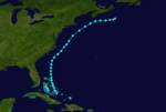
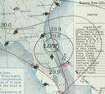
The first storm of the season affected the entire east coast of the United States and parts of maritime Canada. It formed in the Gulf of Mexico in late July and made landfall just north of St. Petersburg, Florida, where gale force winds were reported accompanied by heavy rainfall of up to eight and a half inches. Passing to the northeast, the storm followed the coast, brushing Cape Hatteras on the last day of July, reaching its peak intensity of 70 mph (110 km/h) shortly thereafter, in fact, it may have briefly intensified into a Category 1 hurricane during that time as it transitioned into a post-tropical cyclone. Banking out more to the east after transitioning, the storm passed well away from Cape Cod, turning northward late on August 1 and making landfall in southern Nova Scotia as a weaker system, similar in intensity to when it hit Florida. The storm dissipated over New Brunswick. Minor flooding and crop damage was reported in Florida, but no damage report exists from Nova Scotia.
...
Wikipedia


