Gif-sur-Yvette
| Gif-sur-Yvette | ||
|---|---|---|

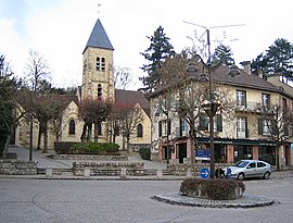
Saint-Rémi church in Gif-sur-Yvette
|
||
|
||
| Coordinates: 48°42′06″N 2°08′02″E / 48.7018°N 2.1339°ECoordinates: 48°42′06″N 2°08′02″E / 48.7018°N 2.1339°E | ||
| Country | France | |
| Region | Île-de-France | |
| Department | Essonne | |
| Arrondissement | Palaiseau | |
| Canton | Gif-sur-Yvette | |
| Intercommunality | Communauté d'agglomération du Plateau de Saclay | |
| Government | ||
| • Mayor (2014–2020) | Michel Bournat | |
| Area1 | 11.60 km2 (4.48 sq mi) | |
| Population (2008)2 | 21,248 | |
| • Density | 1,800/km2 (4,700/sq mi) | |
| Time zone | CET (UTC+1) | |
| • Summer (DST) | CEST (UTC+2) | |
| INSEE/Postal code | 91272 /91190 | |
| Elevation | 57–172 m (187–564 ft) (avg. 61 m or 200 ft) |
|
|
1 French Land Register data, which excludes lakes, ponds, glaciers > 1 km² (0.386 sq mi or 247 acres) and river estuaries. 2Population without double counting: residents of multiple communes (e.g., students and military personnel) only counted once. |
||
1 French Land Register data, which excludes lakes, ponds, glaciers > 1 km² (0.386 sq mi or 247 acres) and river estuaries.
Gif-sur-Yvette is a commune in the south-western suburbs of Paris, France. It is located 22.9 km (14.2 mi) from the center of Paris.
The town is crossed by and named after the Yvette River. The total area is 11.60 km2 (4.48 sq mi) and 4.07 km2 (1.57 sq mi) is green spaces and woods.
The town of Gif-sur-Yvette is composed of sections:
Also, the commune's territory includes many forests such as the Hacquinière Wood and the d'Aigrefoin Wood.
The neighboring communes of Gif-sur-Yvette are : Villiers-le-Bâcle, Saint-Aubin, Saclay, Orsay, Bures-sur-Yvette, Gometz-le-Châtel, Gometz-la-Ville, Saint-Rémy-lès-Chevreuse.
The human presence on the Moulon Plateau originates in Neolithic times. Agriculture was developed, notably during the Roman era.
Between the 12th and the 18th century, an important Benedictine abbey was built in Gif.
In the 19th century, Gif remained very agricultural (in particular, operating mills).
In 1867, Gif was linked to the path of the Sceaux train (which later became the south branch of the RER B).
After the First World War, the Gif commune experienced an important demographic change. The town took the name Gif-sur-Yvette in 1930.
Just after the Second World War, Gif-sur-Yvette acquired an international scientific reputation, with the construction of the CNRS and of the CEA.
...
Wikipedia


