Gometz-le-Châtel
| Gometz-le-Châtel | ||
|---|---|---|
| Commune | ||

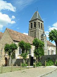
The church of Saint-Clair, in Gometz-le-Châtel
|
||
|
||
| Coordinates: 48°40′41″N 2°08′16″E / 48.6781°N 2.1379°ECoordinates: 48°40′41″N 2°08′16″E / 48.6781°N 2.1379°E | ||
| Country | France | |
| Region | Île-de-France | |
| Department | Essonne | |
| Arrondissement | Palaiseau | |
| Canton | Les Ulis | |
| Intercommunality | Communauté d'agglomération du Plateau de Saclay | |
| Government | ||
| • Mayor (2008–2014) | Stéphane du Crest | |
| Area1 | 5.06 km2 (1.95 sq mi) | |
| Population (2006)2 | 2,119 | |
| • Density | 420/km2 (1,100/sq mi) | |
| Time zone | CET (UTC+1) | |
| • Summer (DST) | CEST (UTC+2) | |
| INSEE/Postal code | 91275 /91940 | |
| Elevation | 83–169 m (272–554 ft) | |
|
1 French Land Register data, which excludes lakes, ponds, glaciers > 1 km² (0.386 sq mi or 247 acres) and river estuaries. 2Population without double counting: residents of multiple communes (e.g., students and military personnel) only counted once. |
||
1 French Land Register data, which excludes lakes, ponds, glaciers > 1 km² (0.386 sq mi or 247 acres) and river estuaries.
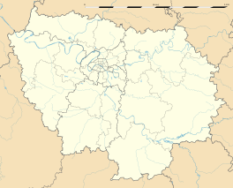
Gometz le Châtel is a French commune in the Essonne department in a southern suburb of Paris 25 km from the center of Paris.
This village is nearby Les Ulis, Bures-sur-Yvette, Gif-sur-Yvette and Gometz-la-Ville, alone the old road from Paris to Chartres, crossing the Hurepoix.
Inhabitants of Gometz le Châtel are called Castelgometziens.
*Official website (French)
...
Wikipedia


