Zvornik
|
Zvornik Зворник |
||
|---|---|---|

Downtown Zvornik and Drina River
|
||
|
||
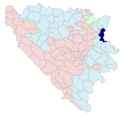
 Location of Zvornik within Bosnia and Hercegovina |
||
| Coordinates: 44°39′N 19°10′E / 44.650°N 19.167°E | ||
| Country | Bosnia and Herzegovina | |
| Entity | Republika Srpska | |
| Government | ||
| • Mayor | Zoran Stevanović (SPRS) (Alliance of Independent Social Democrats) | |
| Area | ||
| • Urban | 376,14 km2 (14,523 sq mi) | |
| Elevation | 146 m (479 ft) | |
| Population (2013 census) | ||
| • City | 12,674 | |
| • Density | 169,3/km2 (4,380/sq mi) | |
| • Urban | 63,686 | |
| Time zone | CET (UTC+1) | |
| • Summer (DST) | CEST (UTC+2) | |
| Area code(s) | 56 | |
| Website | www.opstina-zvornik.org | |
Zvornik (Cyrillic: Зворник, pronounced [zʋɔ̌rniːk]) is a city on the Drina river in north-eastern, Bosnia and Herzegovina. Zvornik is located south of Bijeljina. The town Mali Zvornik ("little Zvornik") lies directly across the river in Serbia.
Zvornik is first mentioned in 1410, although it was known as Zvonik ("bell tower") at that time. The town's geographic location has made it an important trade link between Bosnia and the east. For instance, the main road connecting Sarajevo and Belgrade runs through the city. The medieval fort known as Kula grad was built in the early 7th century and still stands on the Mlađevac mountainous range overlooking the Drina Valley.
During the Ottoman period, Zvornik was the capital of the Sanjak of Zvornik (an administrative region) within the Eyalet of Bosnia. This was primarily the case because of the city's crucial role in the economy and the strategic importance of the city's location. The Sanjak of Zvornik was one of six Ottoman sanjaks with most developed shipbuilding (besides the sanjaks of Vidin, Nicopolis, Požega, Smederevo and Mohač). In 1806, Zvornik was home to Mehmed-beg Kulenović.
Ustasha troops of the fascist Independent State of Croatia occupied Zvornik, along with most of Bosnia, in April 1941. The town was liberated in July 1943 by the 1st Proletarian Brigade during the Battle of Zvornik.
...
Wikipedia

