Zig Zag Railway
| Zig Zag Railway | |
|---|---|
 |
|
|
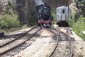
BB18¼ 1072 City of Lithgow in the head shunt at Top Points station |
|
| Locale | Lithgow, New South Wales |
| Terminus | Clarence, Bottom Points |
| Commercial operations | |
| Name |
New South Wales Government Railways Main Western |
| Built by | Patrick Higgins (contractor for NSWGR) |
| Original gauge | 4 ft 8 1⁄2 in (1,435 mm) standard gauge |
| Preserved operations | |
| Operated by | Zig Zag Railway Cooperative |
| Stations | Clarence Mt Sinai Halt No1 Viaduct Top Points Cockerton Bottom Points |
| Length | 7 kilometres (4.3 mi) |
| Preserved gauge | 3 ft 6 in (1,067 mm) |
| Commercial history | |
| Opened | 18 October 1869 |
| Closed | 16 October 1910 |
| Preserved era | 18 October 1975 - October 2013 (second) |
| Preservation history | |
| 1975 | Bottom Points to Top Points section opened 18 October |
| 1987 | Top Points to Mt Sinai section opened 4 April |
| 1988 | Mt Sinai to Clarence section opened 29 October |
| 2011 | Operation suspended |
| 2016 | Limited train movements resume (trackwork) |
| Website | |
| www.zigzagrailway.com.au | |
The Zig Zag Railway is an Australian heritage railway, situated near the town of Lithgow in the state of New South Wales. The line climbs the western flank of the Blue Mountains, using railway zig zags to gain height. It was opened by the not for profit Zig Zag Railway Co-op. Ltd. as an unpaid volunteer staffed heritage railway in October 1975, using the alignment of the Lithgow Zig Zag line that formed part of the Main Western line between 1869 and 1910.
Operation of the heritage railway was suspended in 2012 following accreditation issues with the New South Wales Government. The railway was aiming to resume services in October 2013, but was then severely damaged during the 2013 NSW Bushfires and then subsequently by torrential rain. Repairs are ongoing and trials of restored rail vehicles and track commenced in August 2016 and it is planned to re-commence limited heritage operations in early 2017.
The Lithgow Zig Zag line was constructed as part of the Main Western line and opened on the 19 October 1869. Between Lithgow and Clarence, the Main Western line needed to climb the western flank of the Blue Mountains, overcoming a vertical distance of 550 ft (170 m). The alternative eventually decided upon required the use of two railway zig zags known as Top Points and Bottom Points, where all trains had to reverse. The line had a ruling grade of 1:42 (~2.38%) on three inclines known as the Top Road (above Top Points), Middle Road (between the two zig zags) and Bottom Road (below Bottom Points). The line included several short tunnels and some viaducts.
The steep gradients and need to reverse trains proved to be a serious bottleneck to traffic on the line, and there were several accidents with runaway trains at the reversing points. Attempts were made to mitigate this by realigning the track and relocating and extending the reversing stations, but the problems continued. As early as 1885 plans for alleviating the Zig Zag problem involved the construction of a 2 mi (3.2 km) long tunnel. This was said to provide little gain for the cost proposed. In 1908, work began on the Ten-Tunnels Deviation, a double tracked route that by-passed the two reversing stations and the upper two inclines, although retaining the Bottom Road with its 1:42 gradient. Once this was completed, the by-passed section was closed in October 1910.
...
Wikipedia
