Zapata, Texas
| Zapata, Texas | |
|---|---|
| CDP | |

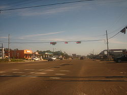
U.S. Highway 83 in Zapata, just south of the intersection with Texas State Highway 16
|
|
 Location of Zapata, Texas |
|
 |
|
| Coordinates: 26°54′22″N 99°16′12″W / 26.90611°N 99.27000°WCoordinates: 26°54′22″N 99°16′12″W / 26.90611°N 99.27000°W | |
| Country | United States |
| State | Texas |
| County | Zapata |
| Area | |
| • Total | 9.6 sq mi (25 km2) |
| • Land | 7.6 sq mi (20 km2) |
| • Water | 2.0 sq mi (5 km2) |
| Elevation | 394 ft (120 m) |
| Population (2013) | |
| • Total | 14,390 |
| • Density | 1,500/sq mi (580/km2) |
| Time zone | Central (CST) (UTC-6) |
| • Summer (DST) | CDT (UTC-5) |
| ZIP code | 78076 |
| Area code(s) | 956 |
| FIPS code | 48-80716 |
| GNIS feature ID | 1350720 |
Zapata is a census-designated place (CDP) in and the county seat of Zapata County, Texas, United States. The population was 5,089 at the 2010 census. As an unincorporated community, Zapata has no municipal government but like all 254 Texas counties has four elected county commissioners chosen by single-member districts and a countywide elected administrative judge.
Zapata was named for José Antonio de Zapata (died 1839), the revolutionary commander who served in the cavalry of the Republic of the Rio Grande, of which the town was a part.
Zapata is located at 26°54′22″N 99°16′12″W / 26.90611°N 99.27000°W (26.906244, -99.270007).
According to the United States Census Bureau, the CDP has a total area of 9.6 square miles (25 km2), of which, 7.6 square miles (20 km2) of it is land and 2.0 square miles (5.2 km2) is water.
The city is located right on Falcon International Reservoir which is at the center of multiple, fishing events throughout the year
The city also served by a number of parks, most notably, Romeo Flores Park.
At the 2010 census, there were 5,089 people, 4,328 households and 1,265 families residing in the CDP. The population density was 629.9 per square mile (243.2/km2). There were 2,239 housing units at an average density of 290.4 per square mile (112.1/km2). The racial makeup of the CDP was 92.38% White, 0.02% African American, 0.06% Native American, 0.18% Asian, 0.00% Pacific Islander, 6.82% from other races, and 0.55% from two or more races. Hispanic or Latino of any race were 94.99% of the population.
...
Wikipedia
