Zaltbommel
| Zaltbommel | |||
|---|---|---|---|
| Municipality | |||

Clockwise from top left: City hall, Saint Martin church, Gasthuis Tower, Gothic house
|
|||
|
|||
 Location in Gelderland |
|||
| Coordinates: 51°48′N 5°15′E / 51.800°N 5.250°ECoordinates: 51°48′N 5°15′E / 51.800°N 5.250°E | |||
| Country | Netherlands | ||
| Province | Gelderland | ||
| Government | |||
| • Body | Municipal council | ||
| • Mayor | Albert van den Bosch (VVD) | ||
| Area | |||
| • Total | 89.04 km2 (34.38 sq mi) | ||
| • Land | 79.61 km2 (30.74 sq mi) | ||
| • Water | 9.43 km2 (3.64 sq mi) | ||
| Elevation | 3 m (10 ft) | ||
| Population (May 2014) | |||
| • Total | 27,242 | ||
| • Density | 342/km2 (890/sq mi) | ||
| Time zone | CET (UTC+1) | ||
| • Summer (DST) | CEST (UTC+2) | ||
| Postcode | 5300–5311, 5315–5318 | ||
| Area code | 0418 | ||
| Website | www |
||
Zaltbommel (Dutch pronunciation: [zɑltˈbɔməl]) is a municipality and a city in the Netherlands.
Zaltbommel was expanded to its current size on 1 January 1999, by a merger of the municipalities of Brakel, Kerkwijk and Zaltbommel. The municipality is situated in the heart of the Netherlands, close to the A2 Motorway, the railway line from Utrecht to 's‑Hertogenbosch and the rivers Waal and Maas.
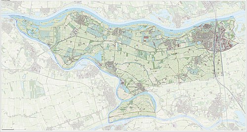
Dutch Topographic map of Zaltbommel (municipality), Sept. 2014
The municipality, consists of 13 population centres and had a population of 27,242 in 2014.
The town of Zaltbommel was first mentioned as "Bomela" in the year 850. Zaltbommel received city rights in 1231 and these were renewed in 1316.
Zaltbommel (in the upper right-hand corner of the image) is situated on the banks of the Waal. Major north-south highways and railways cross the river in the town, just east of the town centre.
1649 map of Zaltbommel in Willem and Joan Blaeu's "Toonneel der Steden"
...
Wikipedia


