Meuse (river)
| Meuse (La Meuse, Mouze, Maas) | |
| River | |
|
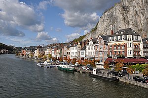
The Meuse at Dinant
|
|
| Countries | France, Belgium, Netherlands |
|---|---|
| Cities | Sedan, Charleville-Mézières, Namur, Liège, Maastricht, Venlo, Grubbenvorst |
| Source | |
| - location | Pouilly-en-Bassigny, Le Châtelet-sur-Meuse, France |
| - elevation | 409 m (1,342 ft) |
| - coordinates | 47°59′12″N 5°37′0″E / 47.98667°N 5.61667°E |
| Mouth | Hollands Diep |
| - elevation | 0 m (0 ft) |
| - coordinates | 51°42′54″N 4°40′4″E / 51.71500°N 4.66778°ECoordinates: 51°42′54″N 4°40′4″E / 51.71500°N 4.66778°E |
| Length | 925 km (575 mi) |
| Basin | 34,548 km2 (13,339 sq mi) |
| Discharge | |
| - average | 350 m3/s (12,360 cu ft/s) |
The Meuse (/ˈmjuːz/; French: la Meuse IPA: [møz]; Walloon: Mouze IPA: [muːs]) or Maas (Dutch: Maas; IPA: [ˈmaːs]) is a major European river, rising in France and flowing through Belgium and the Netherlands before draining into the North Sea. It has a total length of 925 km (575 mi).
From 1301 the upper Meuse roughly marked the western border of the Holy Roman Empire with the Kingdom of France, after Count Henry III of Bar had to receive the western part of the County of Bar (Barrois mouvant) as a French fief from the hands of King Philip IV. The border remained stable until the annexation of the Three Bishoprics Metz, Toul and Verdun by King Henry II in 1552 and the occupation of the Duchy of Lorraine by the forces of King Louis XIII in 1633. Its lower Belgian (Walloon) portion, part of the sillon industriel, was the first fully industrialized area in continental Europe. The Meuse and its crossings were a key objective of the last major German WWII counter-offensive on the Western Front, the Battle of the Bulge (Battle of the Ardennes) in the winter of 1944/45.
...
Wikipedia


